1 Central University “Marta Abreu” of Las Villas, Villa Clara, 50100 Cuba.
2 University of Medical Sciences of Villa Clara (UCM-VC), 50200 Cuba.
Corresponding author email:rigoberto.fimia66@gmail.com
Article Publishing History
Received: 23/02/2023
Accepted After Revision: 18/06/2023
The training of teachers has always been a necessity of the planet aligned to the space and time where this process takes place. Future training of graduates in education, Geography who study geographic space need novel ways to appropriate these contexts and knowledge. The objective of this research was to propose a didactic strategy with the use of virtual didactic itineraries, in the teaching-learning process for the training of education, Geography in the first year of the career: Bachelor of Education. Geography, through the subject Introduction to Labor Practice, which contributed to deepen the knowledge about different landscapes and at the same time developed professional skills related to the study of the landscape. For the development of the research, information collection methods were used (participatory observation, document review, interview, expert criteria) and information processing methods (analysis – synthesis, inductive-demonstrative, logical history, descriptive statistics, modeling and analysis).
The methods allowed to determine the needs of the students from the cognitive, educational and procedural point of view, regarding the teaching-learning process. The didactic strategy was implemented in practice, achieving very satisfactory results from the 2019-2022 academic years. It allows contributing to the development of professional pedagogical skills while deepening the knowledge of different landscapes in the students of the Degree in Education. Geography of the Faculty of Secondary Education of the Central University “Marta Abreu” of Las Villas, Villa Clara, Cuba.
Didactic Strategy; Geography; Labor Practice; Teaching-Learning Process; Virtual Itineraries.
Espinosa O.A, Vallejo E.R, García R.A, Duarte1 R.F. Didactic Strategy for the Use of Virtual Itineraries in the Training of Graduates in Education. Geography. Biosc.Biotech.Res.Comm. 2023;16(2).
Espinosa O.A, Vallejo E.R, García R.A, Duarte1 R.F. Didactic Strategy for the Use of Virtual Itineraries in the Training of Graduates in Education. Geography. Biosc.Biotech.Res.Comm. 2023;16(2). Available from: <a href=”https://bit.ly/2U8EBeg“>https://bit.ly/2U8EBeg</a>
INTRODUCTION
The International Geographical Union and the Commission on Geographical Education (1992, 2000 and 2007) propose International Declarations for the teaching of Geography where proposals are made to promote the idea of fostering knowledge of the environment close to the society where we live. Threats and risks often arise from the lack of knowledge of the inhabitants themselves, from forgetting the history accumulated in each of them (Sánchez, 2020).
The 1992 Declaration outlines that, when selecting geographic content, one can opt for or combine regional studies (e.g., studies of the region, country) or thematic studies (e.g., through the study of physical or human geography, or through centers of interest, such as environmental quality or population growth). In any case, it is pointed out that there should be a balance in the scale of analysis: local, regional, national or global (International Geographical Union and the Commission on Geographical Education, 1992).
The authors of the research consider that it is oriented to study not only the near or local space but also the distant or international space, for which it is necessary to use information and communication technologies for the purpose of teaching Geography, so it is essential for the training of teachers to develop skills related to these media.
This statement also addresses the methods for its teaching, the statement points out that they should stimulate in students the desire to engage in questioning and inquiry. It is essential that students exercise and develop geographical skills with a tendency to search for solutions to the problems posed in the organization of space, present and future (International Geographical Union and the Commission on Geographical Education, 1992).
Another Declaration of great interest is the Seoul Declaration of 2000, which proclaims how geographic education is fundamental for people to develop different capacities in relation to cultural diversity such as:
The ability to defend and be sensitive to human rights;
The ability to understand, accept and appreciate cultural diversity;
The ability to understand, empathize and criticize alternative points of view about people and their social conditions;
To be aware of the impact of their own lifestyles on their social contexts;
Appreciate the need to protect the environment and provide environmental justice to regions and local communities that have suffered environmental devastation;
Ability to act as an informed and active member of both their own society and the global society (International Geographical Union and the Commission on Geographical Education, 2000).
It is a Declaration that insists on intercultural studies from the perspective that geographic education also helps to understand the need to protect the environment at different scales, both local and international, and contributes to educate people active in the global society. (International Geographical Union and the Commission on Geographical Education, 2000).
Subsequently, the 2007 Lucerne Declaration on Geographical Education for Sustainable Development prioritizes issues affecting ecological-holistic thinking, and focuses on three a
The Contribution of Geography to Education for Sustainable Development.
Criteria for Developing a Geographic Curriculum for Education for Sustainable Development.
The Importance of Information and Communication Technologies (ICT) in Education for Sustainable Development in Geography (International Geographical Union and the Commission on Geographical Education, 2007).
This same Declaration emphasizes that the teaching of Geography and Education for Sustainable Development are closely linked, because the acquisition of geographic competencies can improve the understanding of sustainable development. For this reason, it insists on the three competence areas: knowledge, skills and attitudes.
Through geographic knowledge and understanding of natural systems, interaction between ecosystems, and socio-economic systems helps students understand the world through key geographic concepts such as: location, distribution, distance, movement, region, scale, spatial association, spatial interaction, and change over time; Work on communication skills, reasoning, and practical and social skills help explore geographic issues at a range of levels from local to international. With the development of attitudes and values to seek solutions to local, regional, national and international questions and problems on the basis of the Universal Declaration of Human Rights (International Geographical Union and the Commission on Geographical Education, 2007).
Education, in its dynamics, does not escape the significant changes in its teaching-learning process (TLP), by taking into account the growing use of information and communication technologies, as essential elements for the fulfillment of the programs offered by educational institutions (Lima and Fernandez, 2016).
Current education does not take advantage of the technological resources at its disposal, much less, all the possibilities offered by connectivity (Garrison, 2016). Another problem is related to the consensus about the common denomination to express e-learning (Lin et al., 2017).
The authors of this research consider that for the success of this purpose it is necessary to train teachers capable of fulfilling this social task, therefore their training must meet the demands of contemporary Geography teaching. With this purpose of studying the geographic space in an integral way at all scales (global, regional and local), from the ASP, multiple researchers at the international and national level have addressed, in a precise and contextualized manner, the subject matter of the research, the following stand out in recent years (Vilarrasa, 2003; Berger, 2006; Ruiz and González, 2007; Maderuelo, 2007; Sánchez, 2010; Garrido, 2014; Liceras, 2018; Alcántara and Medina, 2019).
Many strategies, projects, research, study programs and other elements such as work practice and field work have been proposed, but there are insufficient proposals from science for the use of connectivity as a teaching tool for the study of landscapes at different scales (Liceras, 2018; Ruiz and González, 2007; Berger, 2006).
From the use of the observation method, it has been possible to observe: weak preparation of the graduates in Education. Geography for the use of virtual didactic itineraries, insufficiencies related to this strategy such as: scarce use of didactic itineraries to promote the study of geographical space and scarce use of local values and technological means available in educational institutions, in addition, geographical knowledge is prioritized while professional skills are little promoted from the (TLP), scarce theoretical and methodological foundations for the use of didactic itineraries to contribute to the training of graduates in education, Geography and the contributions related to the study of geographic space at different scales in a virtual way are insufficient.
In order to carry out this didactic strategy, it is important how this knowledge is transmitted, therefore, active methodologies based on collaborative and/or individual learning are needed. The combination of other teaching strategies and the variety of didactic resources is also a necessity to favor motivation, such as: case studies, field work, didactic itineraries, games and simulations, involving the use of new technologies, handling of Geographic Information Systems, digital cartography, statistical data, use of the web, creation of a notebook, portfolio or dossier, virtual trips, project work, worksheets, analysis of images, stories and poems, creation and solution of problems, among others, that help them to understand and deepen their knowledge, to acquire geographic skills and abilities, and to become aware of the world in which they live, in order to be sensitive to the problems that affect them, both near and far. Elements that should characterize the Geography TLP for the training of graduates in Education, Geography and thus influence the future of the new generations of this society to ensure the Education for Sustainable Development to which we aspire (De la Calle, 2012).
Although different agencies have emphasized the implementation of a sustainable model with an increasing amount of didactic resources, there is still progress to be made in linking science in society. It also states that this is possible through the use of geographic information technologies that allow the creation of virtual databases using virtual globes such as Google Earth and other geometric applications (Oyarce, 2018).
A didactic itinerary is a route or path to follow with different stopping points or points of interest in certain elements of heritage or cultural value. A field trip, previously organized in the classroom by the teacher, and which aims to make a series of stops in those places that you want to make known to the students, but that do not have to be heritage or cultural, because, if we want to know, for example, the commercial activities of a city, such as the market and the different types of existing trade, this didactic tool can also be used (Liceras, 2018; Campo et al., 20l6).
According to the same author, it is a tool that provides the keys to the understanding and teaching of geographic space, constituting rich and deep learning moments that awaken interest, while teaching the student to observe, value and reflect on the surrounding environment (Liceras, 2018).
Virtual didactic itineraries allow the study of various localities through the unobstructed observation of the surrounding landscape and the understanding of the history of the land recorded in rocks, structures, and geographical features (Migon, 2017). In addition, the place is identified from points or sites of interest that allow to recognize and understand a geographical space as a whole according to Palacio et al. (2016).
Taking into consideration what has been expressed in previous paragraphs, the objective of this research is to propose a didactic strategy to use virtual didactic itineraries in the TLP for the training of graduates in Education. Geography.
MATERIAL AND METHODS
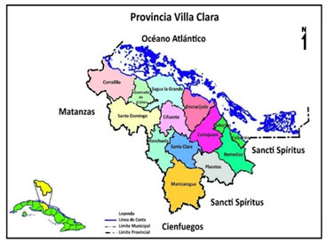
The research was conducted at the Faculty of Pedagogical Sciences “Félix Varela Morales” (Figure 1) of the Central University “Marta Abreu” of Las Villas, in the city of Santa Clara, province of Villa Clara, Cuba (Figure 2).
Figure 1: Satellite photo of the location of the Faculty of Pedagogical Sciences “Félix Varela Morales”
of the Central University “Marta Abreu” of Las Villas, Santa Clara, Villa
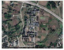
Figure 2: Map of the province of Villa Clara, with its 13 municipalities. Taken from Google Scholar.
For the development of the research, the authors assume the classification of methods given by Bermúdez & Rodríguez (2016) and Expósito et al. (2021). Information collection methods and methods for processing the information collected were used. The information collection methods used were the following:
Participatory observation: to detect the inadequacies of the Teaching-Learning Process (TLP) in the sample and evaluate the transformations experienced by the students during the application of the didactic strategy.
– Document review: to verify the shortcomings and potentialities of the sample and the TLP being developed.
– Interview: to verify the geographic knowledge, professional skills and professional motives and interests of the students before and after applying the didactic strategy.
– Expert criteria: to evaluate the didactic strategy developed and improve it according to the suggestions made by the experts in order to achieve the proposed objective.
An expert is assumed to be a person or persons with experience in the subject, with the capacity to make judgments, criteria and evaluations that allow for the improvement of the proposal developed. The competence of the experts was determined by the K coefficient, calculated according to the opinion of each of the candidates, regarding their level of knowledge on the subject to be addressed and the relations with the sources to argue their criteria (Armiñana, 2020).
Table 1. Level of competence of the experts consulted for the assessment of the strategy.
| EXPERT | K | PROFICIENCY LEVEL |
| 1 | 1 | High |
| 2 | 1 | High |
| 3 | 1 | High |
| 4 | 1 | High |
| 5 | 0,97 | High |
| 6 | 0,89 | High |
| 7 | 1 | High |
The evaluation criteria used to determine the level of competence of the experts were: high competence (0.8 to 1); medium competence (0.5 to 0.7) and low competence less than 0.5. The application of the competence coefficient made it possible to select 7 highly competent experts, on the basis of their knowledge in the training of graduates in Education, Geography and Higher Education.
The aspects on which they had to make their judgment were: objective of the strategy, logical structure, contextualization, contribution to the training of B.Ed., Geography, uniformity for the treatment of geographic knowledge and professional skills in the career of B.Ed. in Geography. Geography.
For the evaluation of these aspects, a scale from 1 to 5 was proposed, where (1) is inadequate, (2), not very adequate, (3) moderately adequate (4) quite adequate and (5) very adequate.
The methods used to process the information collected (intellectual) were as follows:
Analysis-synthesis: to analyze the subject of study, approached by various researchers at national and international level; in the choice of methods; the analysis and synthesis of the results of the initial and final survey, and in the design of the didactic strategy.
– Inductive-demonstrative: to verify from the bibliographic exploration and applied methods, the knowledge, skills and professional pedagogical attitudes of the sample of selected students of the Bachelor’s degree in Education. Geography and to demonstrate the certainty of the research proposal.
– Historical-logical: to implement the theoretical and methodological foundations related to the evolution of the use of virtual didactic itineraries in Cuba and the world.
– Modeling: to model the didactic strategy in the Bachelor’s Degree in Education. Geography; starting from the general objective, the stages, actions and the interrelations among them to fulfill the proposed objective.
The methods of processing the information collected (Statistics) were descriptive statistics for the analysis of frequency distribution tables and elaboration of graphs; which allowed quantifying the results for their subsequent description in the results.
The population coincides with the sample according to the interests of the researchers, and consisted of 14 students, which is the totality of the enrollment of the first year of the Bachelor’s Degree in Education. Geography of the Regular Day Course 2021.
RESULTS AND DISCUSSION
The application of the scientific methods allowed obtaining the following results:
The review of guiding documents such as the Study Plan and Model of the Professional of the Bachelor’s degree programs in Education. Geography, evidenced that the professional skills of landscape interpretation and work with technological media are oriented from the objectives and curricular contents of the career. The use of virtual didactic itineraries as a didactic strategy is not required.
An initial interview was carried out individually with the 14 students of the first year of the Regular Day Course of the Geography career. The objective was to ascertain the geographic knowledge, professional skills and motives and interests of the students about the TLP they would like to receive, as well as the elements that give them pleasure during the Geography TLP.
In the first question related to the geographical phenomena found in a given landscape, only 14.0%, recognized them, but did not establish the relationships between the phenomena that make it up.
In the second question, 10.0% of the students identified the problems of a given landscape, but failed to explain them in context. In the third question, the same number of students recognize the potential of this discipline for the study of geographic space, through virtual itineraries, but none of them managed to exemplify it.
In the fourth question, 3.0% of the sample, in the fourth question, show the professional skills achieved and no student is capable of proposing other examples to develop it in the school. Question 5 addresses the level of satisfaction of the students with the TLP they receive, which is 50.0%.
With this instrument it was evidenced the characteristics that students demand in the TLP for the formation of the future B.A. in Education., Geography, being these:
– Expanding their knowledge.
– Develop cartographic skills.
– Knowledge exchange between students and teachers.
– Collaborative learning.
– Variety of learning environments, both real and virtual.
– Scientific research.
– Search for information from different sources.
– Students as protagonists of this process.
– Use of different forms of organization.
– Varied means of teaching.
– Use of the most effective methods for learning.
– Development of positive human attitudes and values.
With the participant observation of teaching activities, a total of seven were observed, with the purpose of verifying the development of the Geography TLP in the main integrating discipline and the subjects of the academic year, distributed as follows: two of Physical Geography, one of Seminar and another of Lecture, two of Cartography, one Lecture and another Practical Class, three Workshops, two of Work Practice and another of Research Methodology. The following difficulties were identified:
– Scarce treatment of the knowledge of cause-effect and geographical regularities.
– Poor adjustment of the process to the students’ motivations and interests.
– Insufficient linkage of the subjects of the academic year with professional pedagogical skills.
– Scarce technological resources are used.
– Insufficient representations are used to illustrate knowledge.
– A large amount of information is transmitted, with little explanation of how to transmit it.
– Little use of varied learning environments (virtual or real) and at different scales (global, regional and local).
– Insufficient use of knowledge to strengthen emotions, feelings, values and positive attitudes towards the profession.
The analysis of the documents consulted, the results of the interview with students and teachers, as well as the participant observation, made it possible to determine the following Potentialities:
The use of technological means, the study of various spaces and at different scales is included in the normative guiding documents such as Study Plan and Model of the professional of the Bachelor’s Degree in Education. Geography, the use of technological means, the study of various spaces and at different scales.
– The motivation and interest of the students for the profession and the career.
– The experience of the teaching staff.
The main inadequacies in the teaching-learning process of Geography for the formation of the Bachelors in Education, Geography were:
– Little use of the Geography ADP for educational work and the development of professional skills.
– Little use of other forms of organization such as: seminar, practical class, workshop and geographic excursion.
– Insufficient use of the technological resources available to them.
– Insufficient motivation, meaning and involvement of students in learning.
– Insufficient use of the potential of the study plan for the benefit of the Geography teacher’s training.
– Lack of interest by the teacher of how his student learns and how much he contributed to his formation as a teacher and as a man for life in society.
– Insufficient treatment of cause-effect knowledge and geographical regularities.
Based on the results achieved with the applied methods, the didactic strategy is proposed with the use of virtual didactic itineraries in the TLP for the training of graduates in Education, Geography, which was submitted to the experts’ criteria. From the analysis carried out by the experts, the following results are specified:
– 93, 3%, 6 of the experts consulted, estimated that the objective of the strategy was adequate.
– For 5 of the experts, 86.6%, the structure and contextualization of the strategy was very adequate, while the rest considered it to be quite adequate.
– In relation to the actions to achieve unity in the treatment of professional knowledge and skills, only 20.0% considered it to be quite adequate, while 80.0% considered it to be very adequate.
– 93.3% considered the way to establish integration between professional knowledge and skills to be very adequate; only one expert considered it to be not very adequate.
– 100% of the experts consulted agree that the proposal contributes to the training of graduates in Education, Geography of the first year of these careers, they evaluate this aspect as very adequate.
The following are some of the assessments made by the experts. What they expressed has been taken literally.
Expert 1 “I consider that the didactic strategy is pertinent, applicable, shows a logical structure; the professional knowledge and skills have a specific character for the Geography career”.
Expert 2 “The theoretical and methodological conception of the proposal responds to the proposed objective”.
Expert 4 “The actions conceived in stages respond to a logical, coherent procedure, which integrates professional knowledge and skills in correspondence with the professional’s Model”.
Expert 5 “I consider that the strategy is novel and opportune to incorporate students who are starting out in a more dynamic and motivating process, so that they acquire knowledge that they can apply in the profession and in daily life and that a change of attitude is evidenced in them, the transformation into a professional consistent with the world where he/she lives. It is necessary to involve the faculty so that, together with the students, the objective proposed in the strategy can be achieved”.
Expert 7 “The proposal evidences the principles of education and instruction and preparation for life, which are not circumscribed to a career, discipline or year, but should be approached in an integral manner in all university processes, with the participation of students and professors in achieving a better teacher training”.
The criteria, judgments and suggestions issued by the experts were given by: to continue perfecting the actions to achieve an adequate use of the Internet, to establish adjustments for its use in the strategy, taking into account the diagnosis of the group.
After reviewing the proposal by the experts, the researchers made adjustments, reworked the didactic strategy and sent it back to the experts, who evaluated it and expressed that it was pertinent to be applied. The following is the model of the Didactic Strategy designed (Fig. 3).
Figure 3: Didactic Strategy Modeling.
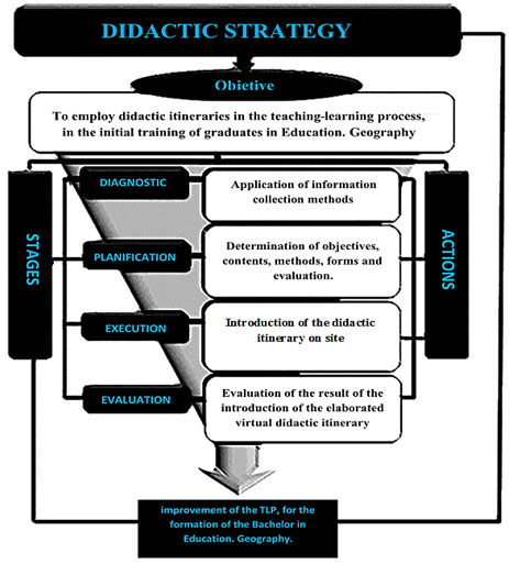
The execution of this didactic strategy was carried out through the use of virtual didactic itineraries in four steps: preparation, research, realization and conclusions, each with specific characteristics, where the student is the protagonist of the activity and the teacher serves as a guide, controller and animator.
Preparation stage.
– It began with the elaboration of a program of Introduction to Labor Practice for the use of virtual didactic itineraries.
– The proposal was presented to the discipline and year group for its approval, planning and integration of different contents and subjects of the year.
– Administrative procedures were carried out.
– The necessary material resources for the activity were organized.
– Virtual didactic itineraries, points of interest or stops were analyzed and selected with the students, using cartographic means, taking into account the combination of different scales: global, regional and local.
– The motivation of the activity was carried out.
– Each of these virtual didactic itineraries was visited and studied in order to know the potentialities and possibilities offered by the networks for their study, as well as to define which one is the most suitable for the proposed objectives.
– A preliminary study of the itinerary to be carried out was carried out.
– The students were organized into study teams and those in charge were selected.
– The information search and scientific research activities carried out by the students in the following stage were planned and oriented, as well as the bibliography they used or the Internet sites they consulted.
In the research stage:
– The teacher examined various means to interest and motivate his students for the topic of the activity.
– The students elaborated and applied research techniques such as: interview, survey or any other that the teacher determined, to specialists or experts on the topic.
– Maps of different scales and themes were consulted to contrast and compare the regularities of the phenomenon in different contexts (digital maps).
– The didactic potentialities of each studied itinerary were determined.
– Students located on maps the areas of study and traced the itinerary to be followed together with their teacher, according to their cognitive interests.
– The students searched for information in different internet sites about the proposed itineraries and elaborated the observation guide for each studied landscape, then compared it with other teams and reached a consensus about the worksheet to be solved during the realization.
– The students, with the help of their teacher, analyzed the information obtained and determined the didactic resources to be addressed during the activity and determined the points of interest during the tour.
– They expressed their opinions about the results obtained in the research.
– A portfolio or dossier was prepared with the information collected, to be consulted in the next stage.
In the realization stage:
– The teacher guided, oriented, directed, proposed, facilitated, asked questions where to direct the observation and what elements to look for, at the end settles the knowledge.
– The students, organized in work teams, investigated what was guided, taking into account the didactic points of interest.
– Procedures such as observing, identifying, describing, inventorying, analyzing, analyzing, understanding, relating, explaining, evaluating, concluding, comparing, extrapolating, generalizing and enjoying while learning were developed.
– The perception of the landscape was enhanced through the following sequence: perceive-observe-read-analyze-conclude, from different angles of vision or perspectives.
– The observations, descriptions and activities carried out made up the reading of the study landscape.
– Virtual spatial boundaries were established.
– The most relevant elements of the landscape were distinguished and described, going through the entire study area.
– The observation and perception of the landscape was compared with the research carried out.
– A common objective perspective was established for all.
– The reading of the landscape began taking into account the following levels: perception, analysis, structure and application.
– The points of interest were located and located with the use of the superimposition of images and digital maps.
– A dense description of the landscape was made, taking into account the relationship between components, causes and reasons for processes and phenomena.
– The didactic principles of Geography were addressed, such as: location, distribution, permanence, change and continuity.
– The aesthetic, patrimonial and identity values of the study landscape, the history and traces of history in it were specified.
– Nature-society relationships were established, environmental damage was identified and actions to minimize it were proposed.
– Interdisciplinary relationships were established.
– The causes of the processes and phenomena studied were understood, explained and valued, taking into account the contents studied, observed and investigated as a result of thinking.
– The feelings experienced during the activity, the elements that provoked those emotions, as well as the most significant lived experiences for the students were described.
– The study of global spaces and local landscapes, as well as the virtual local, were compared with the real local.
– Human values such as solidarity, responsibility, love of nature, humility, honesty, patriotism, sense of belonging and identity were strengthened.
– Professional skills and didactic procedures were developed and the didactic potentialities of the activity were addressed, as well as its contribution to their training.
– An integral evaluation of the studied space and its potentialities for the development of the Geography teaching process was carried out.
In the conclusion stage.
– Conclusions were reached and the fulfillment of the objectives of each didactic itinerary was verified.
– The experience was reflected and recapitulated, deepening in the contributions of the activity to the integral formation of the students.
– The results were presented in the form of seminars or round tables.
– The presentation of the work was organized in exhibitions or publications where there were exhibitions of samples of natural elements, photographs, creative works made by the students, posters, murals, banners, collages, models, maps or computer products, such as web pages or interactive blogs or publications in social networks and creation of groups.
– The teacher evaluated his students, comprehensively and individually, taking into account their evolution during the whole process of the activity.
– The activities carried out were specified, the best and most complete works were selected, as well as the most outstanding students and teams in the activity. In addition, the main difficulties and achievements were specified and the students proposed goals for the next virtual didactic itinerary.
At the end of these steps and actions, a new one is started, which allowed its improvement throughout the research. A total of 6 virtual didactic itineraries were carried out, which make up this elaborated didactic strategy. At the end of its application, a final interview was applied to the students of the first year of the Bachelor’s Degree in Education. Geography, with the objective of verifying the geographic knowledge and professional skills acquired and the degree of satisfaction they have in relation to the actions developed. The results obtained are presented below.
The first question related to the total determined, 99.0% of the students answered satisfactorily. Regarding the recognition of environmental problems and explanation of the same in the context (second question), 97.0% already do it correctly.
100.0% of the students recognize the potential of this discipline for the study of geographic space and exemplified it (question 3).
Question 4, which refers to the professional skills achieved, 99.0% manage to do it correctly and 90.0% are able to propose other examples to develop it at school.
Figure 4: Results of the interviews before and after applying the strategy.
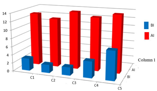
Question 5 addresses the students’ level of satisfaction with the process achieved, reaching 100%.
The graph (Fig. 4) shows the satisfactory results achieved by the students after applying the didactic strategy.
The results showed that the students in the sample acquired geographic knowledge while developing professional skills, according to the requirements of the TLP of Higher Education. From the actions carried out, it was possible to contribute to the formation of graduates in Education, Geography with greater deepening and integration of knowledge to a geographic space and how to carry out similar activities in the students of the Geography career in the Faculty of Secondary Education of the Central University ”Marta Abreu” of Las Villas, Villa Clara, Cuba.
In the research process, it was possible to confirm that the use of virtual didactic itineraries is an effective, efficient and effective didactic strategy for the training of graduates in Education. Geography, as part of the initial training of this professional, where the teacher is the most important element in the intellectual, affective and moral formation, focused on achieving changes in attitudes in the subjects involved, which does not differ from what is expressed by (Marrero and Méndez, 2018).
As results of the use of virtual didactic itineraries in the teaching-learning process for the training of Bachelors in Education. Geography the authors consider that:
It contributed to enhance the training of future Bachelors in Education. Geography in the following elements: greater participation of the students, as active agents within the process; they became researchers at the same time they acquired new knowledge; they were motivated and interested not only in Geography but also in their profession; this form of professional performance became a reference for them; it promoted the search for these particularities in their localities and the study of them; it promoted the systematic application of this form of professional performance; strengthened values and positive attitudes for a culture of TLPce; promoted Education for Sustainable Development; developed professional skills and the ability to solve problems related to their profession; promoted the use of technologies as a means of teaching, the use of social networks; favored the development of skills such as observing, describing, explaining, characterizing, arguing and valuing; developed the perception of the landscape.
The influence of these technological tools in the TLP is evident in self-learning, the acquisition of knowledge, the development of personal and interpersonal skills, the promotion of creativity, and the stimulation of collaborative and committed attitudes, in addition to the use of technologies focused on the landscape as an educational resource (Botella and Hurtado, 2016). The combination of strategies and skills contributes to the achievement of different objectives, competencies and contents that characterize the training process of future teachers. In order to teach school geography, didactic itineraries are an important resource that should be known and practiced as active teaching. In addition, it promotes motivation in students to disconnect the rhythm and routines of daily classes or to discover new emotions by performing different experiences (Campo et al., 2016).
There is correlation between students’ effort, active participation in the virtual environment and reading the document prepared by the student with the evaluation of their academic performance (Dominguez et al., 2016).
The teaching-learning process contributed to the study of different geographical spaces at different scales, as Marrón (2007) points out, when the student is able to explain the diversity of existing spaces, the territorial and social inequalities that occur on the planet and within the countries or nations themselves, the effects that human action is having on Nature and the environment and the causes that motivate them, and try to provide solutions, since it is necessary to put limits to an unlimited development in a space – the planetary – that is limited.
Batllori (2011) suggests the need to combine the large scale with the small scale because it provides a more complex view of reality. The use of virtual tools has advantages such as: lower costs. They are more motivating for learning. It has no defined limits, neither of time nor of space. It can be accessed from anywhere in the world. It can be documented with a great variety of materials and in very diverse formats. It allows unlimited interactivity. It is an experiential experience in which concepts, skills and procedures are developed and emotions are produced. It promotes a deep knowledge of space. It demands the active participation of students. It integrates the stages of traditional fieldwork. It reinforces real observation with digital literacy while obtaining deep knowledge of the place (González and Marrón, 2012).
The authors agree with the criteria expressed by Évora (2011) when he asserts that the strategy, in the educational field, constitutes the pedagogical direction to transform the real state to the desired state of the object to be modified, from the conditioning of the system of actions between the directing subsystem and the directed subsystem to achieve the proposed objectives at its highest level.
We also agree with Charbonet (2009), when he asserts that strategies arise from dissatisfactions or contradictions between the actual and the desired state, pursue defined objectives, are organized by stages, require transforming actions that cause changes in the actual state and in their conception are present control and feedback mechanisms. In this sense, the didactic strategy assumes the postulates issued by these authors.
For Chávez et al. (2019) and coinciding with Orfa et al. (2019), the strategy becomes the teacher’s actions with the purpose of facilitating training and learning, using didactic techniques which allow building knowledge in a creative and dynamic way.
The actions implemented in the didactic strategy influence the transformation of the personality of the future teacher of Geography; manifested in the acquisition of knowledge, its implementation in new situations, teamwork for the solution of problems related to the pedagogical task, willingness for active and conscious participation in environmental activities, and the planning, preparation and implementation of actions that can be put into practice from the Cuban school.
The criteria issued by the teachers and experts consulted ratify the importance of the studies conducted by Villamandos et al. (2019), related to the search for alternatives as the didactic strategy for the development of the TLP in Geography students.
The strategy perfected how to express the scientific results achieved by the students in order to socialize them, which can be applied in performance contexts similar to the one in which the research is developed; in the opinion of the researchers, actions should be conceived in the strategy that involve Educational Research Methodology, which is the subject that has within its task, to prepare the student for this purpose.
The authors agree with García & Reques (2012) about the use of these tools in the teaching of Geography where it should be kept in mind that the Internet is a means not an end, that data should not be confused with information, nor information with knowledge.
In addition, García and Pascual (2012) point out the dual role of the teacher as a model of discipline, authority and for teaching to think, and as a social animator who creates learning situations and promotes their development in an adequate manner. It is also necessary to count on the disposition of students towards learning with the use of Information and Communication Technologies.
In this regard, Esteban et al. (2018) expressed about adapting to the changes that today’s society demands, where the master class has already been left behind to give way to the class with technological, audiovisual and interactive media, which has greater prominence.
On the other hand, the training of students must be in accordance with today’s society, in an integral way where it enables them to apply professional knowledge, in a responsible and regulated way under the respect, not only to the procedures and adequate decision-making processes, but also within the respect for values and attitudes proper to the profession such as professional ethics, as expressed by González and Méndez (2017), elements with which the researchers agree.
In conclusion, the actions applied as a result of the didactic strategy contributed to improve the TLP in the students of the first year of the Regular Day Course of the Geography career of the Faculty of Secondary Education of the Central University “Marta Abreu” of Las Villas.
REFERENCES
Alcántara, M.J., Medina, Q.S. (2019). El uso de los itinerarios didácticos (SIG) en la educación ambiental. Enseñanza de las ciencias (Innovaciones didácticas). Córdoba, España. 37 (2): 173-188. https://doi.org/10.5565/rev/ensciencias
Armiñana, G.R., Fimia, D.R., Castillo, F.Y., López, P.R.T., Fernández, P.J.A., Iannacone, J. (2021). Lissacathina fulica (Bowdich, 1822) (Mollusca: gastropoda: Stylommatophora: Achatinidae), amenaza los ecosistemas cubanos y la salud humana. Neotropical Helminthology 15(1): 41-55.
Armiñana, G.R., Castillo, F.Y., Mesa, C.N., Fimia, D.R., Leyva, H.J., Iannacone, J., Durán, F.Y., Fábrega, O.G. (2020). Nueva concepción didáctica para el proceso de enseñanza – aprendizaje de la Zoología de los cordados. PAIDEIA XXI 10: 33-57.
Batllori, R. (2011). Enseñar y aprender el espacio geográfico” en Santisteban, A. & Pagès, J. Coords.) Didáctica del Conocimiento del Medio Social y Cultural en la Educación Primaria. Síntesis, Madrid, p. 249-268.
Botella, N.A.M., Hurtado, A. (2016). Formación del profesorado en innovación educativa. La experiencia de L´Hort 2.0. Aulas virtuales: fórmulas y prácticas. Universidad de Valencia, España. 13 pp.
Campo, P.B., Rodríguez, P.L.A., Colomer, R.J.C. (2016). Enseñanza de itinerarios geográficos para el estudiante de magisterio; propuestas de aprendizajes autónomo en el aula universitaria y en el Geo foro iberoamericano. En Nativos digitales y Geografía en el siglo XXI; educación geográfica y estilos de aprendizajes Universidad de Valencia y Colombia. 142 pp.
Charbonet, M.E. (2009). Mejoramiento del desempeño profesional pedagógico para la educación ambiental de los profesores de ciencias naturales de los preuniversitarios. Una estrategia pedagógica [Tesis de doctorado, Universidad de Ciencias Pedagógicas “Enrique José Varona”, La Habana, Cuba]. 228 pp.
Chávez, L.E.D., Chávez, M.N., Villafuerte, M.J.A. (2019). Estrategia Pedagógica de educación ambiental en función de una vida saludable en la Universidad de Guayaquil. Revista Conrado 15(70): 63-66 http://conrado.ucf.edu.cu/index.php/conrado
De la Calle, C. (2012). La enseñanza de la Geografía ante los nuevos desafíos ambientales, sociales y territoriales. La educación geográfica digital. Universidad de Valladolid, España. Grupo de Didáctica de la Geografía de la Asociación de Geógrafos Españoles. 123-137 pp. Disponible en: http://www.age-didácticageografía.es/
Domínguez, D., Alvárez, J., Gil-Jaurena, J. (2016). Analítica del aprendizaje y Big. Data: heurísticos y marcos interpretativos. International Journal of Applied Ethies 22: 87-103. http://www.dilemata.net/revista/index.php/dilemata/aeticle/view/412000042/450
Esteban, S.N., Rivas, R.B., Sánchez, M.R., Cáceres, T.C. (2018). Itinerarios formativos para docentes URJC on-line. Centro de Innovación en Educación Digital: URJC online. Universidad Rey Juan Carlos Móstoles, Madrid, España. 157-159 pp. Disponible en: http://riull.ull.es/xmlui/handle/915/8045
Évora, O.E. (2011). La educación ambiental para el desarrollo sostenible en la formación inicial de los profesionales de la educación en el proceso de enseñanza-aprendizaje de la física. [Tesis en opción al grado científico de Doctor en Ciencias Pedagógicas, Universidad de Ciencias Pedagógicas “Félix Varela”, Villa Clara, Cuba]. 212 pp.
Expósito, M., Armiñana, R., Fimia, R., Gómez, M. A., Artiles, L. A., Olivera, D., Iannacone, J., Carballo, B.M. (2021). Vinculando a los escolares de la enseñanza media al conocimiento de las especies exóticas invasoras de origen vegetal en Cuba. The Biologist (Lima) 19(2): 175-185.
Fernández, N.F.A., Lima, M.S. (2017). La educación a distancia en entornos virtuales de enseñanza aprendizaje. Reflexiones didácticas. Atenas 3(39): 31-47. Disponible en: https://www.redalyc.org/articulo.oa?id=478055149003
García, P. (2012). Posibilidades de la plataforma IDERioja para el análisis de la ciudad de Logroño. La educación geográfica digital. Universidad de La Rioja, España. Grupo de Didáctica de la Geografía de la Asociación de Geógrafos Españoles. 65-72 pp. Disponible en: http://www.age-didácticageografía.es/
García, R. (2012). Los desafíos futuros de la población mundial: materiales para su análisis y discusión en el aula. La educación geográfica digital. Universidad de Barcelona y Cantabria, España. Grupo de Didáctica de la Geografía de la Asociación de Geógrafos Españoles. 131-157 pp. Disponible en: http://www.age-didácticageografía.es/
Garrido, P.F. (2014). Topofilia, paisaje y sostenibilidad del territorio. Enrahonar. Quaderns de Filosofía 53. Andalucía. España. 63-75 pp.
Garrison, D. (2016). ELearning en el siglo XXI. Un marco comunitario de investigación y la práctica. New York, Estados Unidos. Revista Iberoamericana de Educación a Distancia 23(1): 09-28. Disponible en: http://dx.doi.org/10.5944/ried.23.1.25495
González, M. (2017). Desarrollo de un Prácticum virtual: fundamentos y clases. Revista Prácticum 2(2): 50-68.
Hernández, F.M., Cárdenas, G.M., Armiñana, G.R., Fimia, D.R., Iannacone, J. (2021). El trabajo de campo: una herramienta para la enseñanza del patrimonio y la historia local. Biotempo 18(1): 21-35.
International Geographical Commission, Commission on Geographical Education. (1992). International Statement on Geographical Education. 160-162 pp. Available at: http://www.raco.cat/index.php/RevistaGeografi a/article/viewFile/46086/56892.
International Geographical Union. Commission on Geographical Education. (2000). International Declaration on Geographic Education for Cultural Diversity. 195-200 pp. Available at: http://www.agegeografia.es/v2/diversidad_cultural.php?TB_iframe=true&height=430&width=70
International Geographical Union. Commission on Geographical Education. (2007). International Declaration on Geographical Education for Sustainable Development. 217-240 pp. Available at: http://www.igu-cge.org/Charterspdf/spanish.pdf
Liceras, A. (2018). Los itinerarios didácticos en la enseñanza de la Geografía. Reflexiones y propuestas acerca de su eficacia en la Educación. Revista de la Universidad de Granada, España. Universidad, Escuela y Sociedad 5: 66-81.
Lin, C., Liu, K. (2017). A study of the effects of digital learning on learning motivation and learning outcome. Eurasia Journal of Mathematics, Science and Technology Education 13(7): 3553-3564.
Maderuelo, J. (2007). El paisaje. Génesis de un concepto. Editorial Abada. Madrid, España. ISBN 9788-4962-5856-3. 344 pp.
Marrero, R D., Santos, I.E. (2018). Aproximación a los valores del educador ambiental. Revista Humanidades Médicas 19(1): 160-179.
Marrón, G.M.J. (2007). Desarrollo sostenible, globalización y educación en valores ambientales desde la geografía. Una propuesta metodológica en el marco europeo de Educación Superior. En Marrón Gaite, Mª J. Salom Carrasco, J. & Souto González, X.M. (Eds.) Las competencias Geográficas para la educación ciudadana, Valencia: Grupo de Didáctica de la AGE- Universidad de Valencia, p. 133-146.
Marulanda, N., Rojas, M.D. (2019). Ética en Instituciones de Educación Superior para la Construcción de Relaciones de Confianza con Grupos de Interés (Stakeholders). Información Tecnológica 30(3): 269-276. Disponible en: http://dx.doi.org/10.4067/S0718-07642019000300269
Migon, P. (2017). View point geosites-values, conservation and management issues. Proceedings of the Geologists´ Association, volume Elsevier Ltd 128, Issue 4. 518-522 pp. Disponible en: https://doi.org/10.1016/I.pgeola.2017.05.007
Orfa, R.M., Garzón, RL., Pinzón, M.L., Salamanca, A.L., Pabón, L.C. (2019). Estrategias pedagógicas como herramienta educativa: la tutoría y el proceso formativo de los estudiantes. Revista Iberoamericana de Educación 50 (3): 1-16. Disponible en: https://doi.org/10.35362/rie5031869
Oyarce, A. (2018). Caracterización, valoración y promoción de la geodiversidad del sendero Sierra Velluda en el parque nacional Laguna del Laja mediante la creación de un itinerario geológico virtual utilizando Google Earth y código QR. Facultad de ingeniería de la Universidad “Andrés Bello”, Concepción, Chile.
Palacio, J., Sánchez, J., Schilling, M. (2016). Patrimonio geológico y su conservación en América Latina: situación y perspectivas nacionales. Instituto de Geografía de la Universidad Nacional Autónoma de México. Colección: Geografía para el siglo XXI. Serie: Libro de investigación, No 18. 659-668 pp.
Sánchez, R. (2020). Proyecto de Innovación docente para la educación patrimonial en Madrid. Innovación educativa en la sociedad digital. Madrid, España. s/p. Disponible en: https://www.ucm.es/proyectos-de-innovación-2019-20
Seoul Declaration of 2000. In: International Geographical Union. Commission on Geographical Education. 2000. International Declaration on Geographic Education for Cultural Diversity. 195-200 pp. Available at: http://www.agegeografia.es/v2/diversidad_cultural.php?TB_iframe=true&height=430&width=70
Vilarrasa, A. (2003). Salir del aula. Reapropiarse del contexto. Revista Iberoamericana 36: 13-25.
Villamandos, F., Gomera, A., Antúnez, M. (2019). Conciencia ambiental y sostenibilización curricular, dos herramientas en el camino hacia la sostenibilidad de la Universidad de Córdoba. Revista de Educación Ambiental y Sostenibilidad 1(1): 13-25. Doi: 10.25267/Revista_educación_ambiental _sostenibilidad. 2019. v1.i1.1301