Olesya I. Grigoreva1![]() , Olga A. Marinina
, Olga A. Marinina![]() 2 and Evgeniya Ya. Zelenskaya
2 and Evgeniya Ya. Zelenskaya![]() 2
2
1Belgorod Department of Agro-Industrial Complex and Reproduction of the Environment, 308000, Belgorod, Russia
2Federal and regional centre for aerospace and surface monitoring of the objects and natural resources, Belgorod State National Research University, 308015 Belgorod, Russia
Corresponding author email: Zelenskaya@bsu.edu.ru
Article Publishing History
Received: 08/02/2020
Accepted After Revision: 25/03/2020
This article contains an assessment of the historical data on the land resources of the Belgorod Region with a breakdown by municipal districts. Some historical documents from the State Archive of the Belgorod Region and the recent reports on the land status and use of the Belgorod Region Office of the Federal Service for State Registration, Cadastral Records and Cartography (Rosreestr) were used to analyse the spatial and temporal changes in the structure of the land resources. The land area was quantitatively analysed by categories. The degree of transformation of the land resources was evaluated. The historical data on the commercial lands is presented using GIS application ArcGIS 10.2, including the use of toolkits Spatial Analyst and Spatial Statistics. Anthropogenic load was assessed with the use of multidimensional cluster analysis methods (Wardʼs method). For the development of information base on transformation of the land resources in the territory of municipal districts of the Belgorod Region a time interval from the formation of the region (1954) until 2017 was used. During this, period significant changes occurred in the structure of the land resources. The area of the arable land was reduced by 7.8%. The area of natural forage and forestlands increased by 17.1% and 13.2% respectively. The area of land occupied by industrial buildings and built-up territory has increased by 31.2%. The area of land under water facilities has increased by 133.2%. The dynamics of land transformation under swamps is unstable. Drainage of swamps and their transformation into hayfields and pastures has reduced the amount of wetland by 12% for the period from 1954 to 1975. Wetlands in floodplains are reported to be increased by 25.2% since 1976. The areas under perennial plantations (14.3%) and disturbed lands, which are unsuitable for agricultural use (11.6%), have slightly decreased. The municipal districts are divided into three large clusters by cluster analysis. The determinant classification criterion is spatial and temporal change in land resources over 63 years. The municipal districts of the Belgorod Region have been typified by historical data on land and resource potential of agricultural landscapes.
land fund, anthropogenic impact, land transformation, land monitoring.
Grigoreva O. I, Marinina O. A, Zelenskaya E. Y. Spatial and Temporal Changes in the Land Resources of the Belgorod Region from 1954 To 2017 Under the Influence of Anthropogenic Factors. Biosc.Biotech.Res.Comm. 2020;13(1).
Grigoreva O. I, Marinina O. A, Zelenskaya E. Y. Spatial and Temporal Changes in the Land Resources of the Belgorod Region from 1954 To 2017 Under the Influence of Anthropogenic Factors. Biosc.Biotech.Res.Comm. 2020;13(1). Available from: https://bit.ly/2HkuUPG
Copyright © Grigoreva et al., This is an Open Access Article distributed under the Terms of the Creative Commons Attribution License (CC-BY) https://creativecommons.org/licenses/by/4.0/, which permits unrestricted use distribution and reproduction in any medium, provide the original author and source are credited.
INTRODUCTION
The significant rates of build-up of the gross regional product of the Belgorod region, which is mainly, composed of manufacturing, agriculture and forestry, mining, as well as increase in agricultural production in the crop and livestock sectors influences substantially on the state of land resources in the agricultural landscapes of the Belgorod region. This region is not only agricultural with the share of arable land being more than 60% of the total area of the territory, but also an industrial zone. However, disturbed lands (ferrous metallurgy quarries, construction material production facilities) make up 14.1% in the total share of industrial and other special purpose lands. It is essential to analyse the interaction between man and nature in a comprehensive way, to evaluate the ecological and resource state of agricultural landscapes, to classify and to typify those (Lisetsky et al., 2015).The data on quantitative changes in the Belgorod Region lands are constantly updated. The rates of anthropogenic degradation of vegetation and soils have already been established (Chendev et al., 2008; Chendev et al., 2016; Zelenskaya et al., 2019).
We have brought up to date the historical data on woodlands (Kuzmenko et al., 2013, Degtyar and Grigoreva, 2018), including according to satellite survey materials (Terekhin and Chendev, 2018), calculated natural grassland area variation (Kitov, 2015, Kitov and Tsapkov, 2015), evaluated the fallow area (Marinina et al., 2013), covered broadly in the paper the issues related to the development of urban agglomerations (Chugunova et al., 2019), analysed the structural transformation of the suburban areas of the Belgorod agglomeration in the paper (Tsapkov, 2016) and assessed the dynamics in the structure of the land resources of the Belgorod Region (Grigorieva, 2017 a, b). The accumulated data bank on qualitative and quantitative changes in the land cover (Shtompel’ et al., 1998, Lisetskii et al., 2016, Lisetskii, 2019) is needed to manage land and property relations, to carry out monitoring functions in relation to the land resources and the entire ecological environment of the Belgorod region.
Typological diversity of the river basins of the European Russia (Yermolaev et al., 2018) calls for the development of adapted systems of water and land use (Lisetskii et al., 2014 a, b; Pozachenyuk et al., 2015, 2018, Grigoreva and Buryak, 2016, Buryak and Grigoreva, 2019). Land cover transformation is a dynamic process in the land and property system (Srivastava et al., 2010), and its cumulative effect affects the life-sustaining functions of the Earth’s biomes (Chhabra et al., 2006) as well as has socio-economic consequences (Shifaw et al., 2019).
One of the main lines of global socio-economic and environmental studies is the development of land monitoring system, including specific monitoring activities for the study of land cover dynamics changes (Zhou and Kang, 2011). It is essential to have available definite sets of estimated data on land cover condition and use in order to study environmental changes, to manage land resource, to forecast and to simulate sustainable development of territories (Cai et al., 2011, Manakos et al., 2017, 2019).
The limited land resources and the growing need for their use cause dissonance between stakeholders, which requires continuous correction of decisions in land management (Felsenstein and Lichter, 2014). The priority land management task is to integrate historical approach into land potential evaluation (Fischer and Black, 1995, Zia, 2012, Rinfret and Pautz, 2014, Comber et al., 2016, Bao et al., 2019).
It is impossible to have long-term research, improvement and forecasting in land monitoring system without the use of geoinformation approaches (Grigoreva, 2015); in particular, remote sensing is the most important source of data for agricultural monitoring mapping (Teluguntla et al., 2018, Nduati et al., 2019). GIS-approach is largely based on the integrated use of different types (Terekhin, 2016, 2018) of a multi-time set of satellite medium-resolution data (250 m or more) and a time-limited high-resolution set (Landsat 30 m) (Nduati et al., 2019).
MATERIAL AND METHODS
Study area: The study included all land resources of the Belgorod Region with their breakdown by municipal districts. The Belgorod Region has an area of 27100 km2 and it is located in the Central Federal District of the Russian Federation. It is located on the south-western spurs of the Central Russian Upland and it is an elevated plain, which is uplifted in the northern part and has mild slopes to the west-south-west and east-south-east (Lisetskii et al., 2015). The slope type terrain prevails on the territory of the region (48% of the area) (Yudina, 2013). The share of agricultural land in the region is 78.8%, including 60.8% of arable land, 12.7% of forest area, 1.7% of land under water facilities and 4.6% of land under buildings and roads and 2.2% (data from the Rosreestr Administration for the Belgorod Region for 2017) of disturbed and other land not suitable for agricultural use. The erosion of arable soils is distributed unevenly, within the region it increases from 25 to 50% from west and north-west to east and south-east (Spesivy and Lisetskii, 2014).
Data used:Historical documents: A data set for the analysis of historical changes in the structure of the land resources is collected from the documents of the State Archive of the Belgorod Region. We have used 266 annual reports on the condition and use of the Belgorod Region lands, as well as plans and reports on land planning and reclamation works, information on the condition of the forest resources, information on the number and distribution of acreage. These materials are collected for each municipal district and have a time interval from 1954 (year of foundation of the region) to 2017.
Modern documents: We have obtained up-to-date information on land condition and use from the Rosreestr Office for the Belgorod Region for the period from 2010 to 2017, which has also become an important source of data.
Methods: Information on quantitative indicators of the land resources has been collected in 21 districts for six temporary sections (1954, 1965, 1975, 1985, 1995, 2005, 2017). A quantitative land area analysis has been carried out by land categories, which has made it possible to assess land transformation. The extent of changes in land areas is shown on map charts with the use of GIS technologies. We have used a multi-functional GIS application ArcGIS 10.2, including tool sets Spatial Analyst and Spatial Statistics, as a software product. Anthropogenic load was assessed with the use of multidimensional cluster analysis methods (Wardʼs method).
RESULTS AND DISCUSSION
An analysis of historical documents and current records on the structure of the land resources of the Belgorod Region for the period 1954-2017 has shown a positive increase for natural grassland, forests, and lands under industry, roads and buildings, lands under wetlands. A negative growth has been reported for arable land, perennial plantations and disturbed lands not suitable for agricultural use (Table 1).
Table 1. The dynamics of the land fund of the Belgorod region
| Commercial lands | Time slice | Total*
+/- |
||||||||
| 1954 | 1955-1965 | 1966-1975 | 1976-1985 | 1986-1995 | 1996-2005 | 2006-2017 | ||||
| Positive increase | ||||||||||
| Natural forage land | ha | 388194 | +47720 | -8764 | +3605 | +27222 | +943 | -4316 | +66410 | |
| % | – | +12.3 | -2.2 | +0.9 | +7.0 | +0.2 | -1.1 | +17.1 | ||
| Forests and forest strips | ha | 293428 | +8911 | +3916 | +6110 | +16278 | +3487 | 0 | +38702 | |
| % | – | +3.0 | +1.3 | +2.1 | +5.6 | +1.2 | 0 | +13.2 | ||
| Land under industry, roads and buildings | ha | 95941 | +4228 | +8353 | +5177 | +14962 | -2331 | -402 | +29987 | |
| % | – | +4.4 | +8.7 | +5.3 | +15.6 | -2.4 | -0.4 | +31.2 | ||
| Land under water | ha | 11001 | +104 | +4560 | +5214 | +4080 | +298 | +396 | +14652 | |
| % | – | +0.9 | +41.5 | +47.4 | +37.1 | +2.7 | +3.6 | +133.2 | ||
| Lands under the swamps | ha | 18021 | -1482 | -669 | +2136 | +4620 | -116 | +39 | +4543 | |
| % | – | -8.2 | -3.7 | +11.8 | +25.7 | -0.6 | +0.2 | +25.2 | ||
| Negative growth | ||||||||||
| Arable land | ha | 1791295 | -44076 | -20516 | -17939 | -47305 | -8040 | -1969 | -139845 | |
| % | – | -2.5 | -1.2 | -1.0 | -2.6 | -0.4 | -0.1 | -7.8 | ||
| Perennial plantings | ha | 39833 | -560 | -2967 | -3700 | -11285 | +8913 | +3911 | -5688 | |
| % | – | -1.4 | -7.4 | -9.2 | -28.3 | +22.4 | +9.8 | -14.3 | ||
| Disturbed land unsuitable for agricultural use | ha | 75729 | -11051 | +15812 | -1253 | -11582 | -2478 | 1758 | -8794 | |
| % | – | -14.6 | +20.9 | -1.7 | -15.3 | -3.2 | +2.3 | -11.6 | ||
| Note: * dynamics of the land area achieved by 2017 relative to the values of 1954. | ||||||||||
A high share of arable land in the region has required managers and farmers to take measures to preserve land resources. As a result, since 1954 one can see ongoing land transformation with its highest peak being from 1966 to 1985. The in-house land use planning interventions by collective and communal farms (1964-1997) has resulted in reduced arable land mainly due to reclamation works (transformation of unproductive arable land for hay and pastures, the development of anti-erosion forest strips and forested areas). As a result, by 2017 the area of natural forage land increased by 17.1% as compared to 1954. Over the same period, the area of forest plantations has consistently increased and cumulatively made up 3%, 4.3%, 6.4%, 12%, and by 2017 this figure reached 13.2% due to large forest cover percent of degraded and erosion-hazardous lands. The biggest increase in forest cover was reported to be in the period from 1986 to 1995. This decade more than 16,000 hectares of forest crops were planted.
Land areas under industry, roads and buildings also increased. Their share became higher by 31.2% by 2017 as compared to 1954. The land of this type was reported to be increased between 1954 and 1995, then starting from 1996 its area was reduced by 2.8%, which was possibly related to some errors in statistical records, and it is these lands that were partially counted as disturbed lands not suitable for agricultural use.
The area of land under water facilities (by 133.2%) is reported to be increased drastically throughout the region. This is due to beams flooding and the development of ponds, which have come to be used for irrigation of agricultural fields.
It is reported to have a negative land growth for arable soil, perennial plantations and disturbed land not suitable for agricultural use. The area of arable land was annually reduced, and totally decreased by 7.8% over 63 years (by 2017). At the same time, there are significant annual losses of arable land because of its transfer to medium-stabilizing lands. The author has found that in each decade (for the period from 1954 to 1995) the area of arable land decreased by 2.5%, 1.2%, 1.0%, 2.6%, then the rate of reduction of arable land was lower and over the next 20 years (1996-2017) it made up only 0.5%. This process is related with renewal of land and property relations in the Russian Federation and the transition from a controlled economy to a market one. The area of land under perennial plantations showed progressive decreasing tendency (14.3%). This process was related with reduction in mulberry plantings, vineyards and orchards, which have lost their life cycle. The area of disturbed land not suitable for agricultural use also decreased by 11.6%.
An analysis of statistical land records has made it possible to differentiate municipal districts by dynamic changes in quantitative parameters of the land structure using GIS tools. As a result, we have developed a number of map charts for spatial and temporal land distribution in the Belgorod Region (Figure 1, a-f)[1].
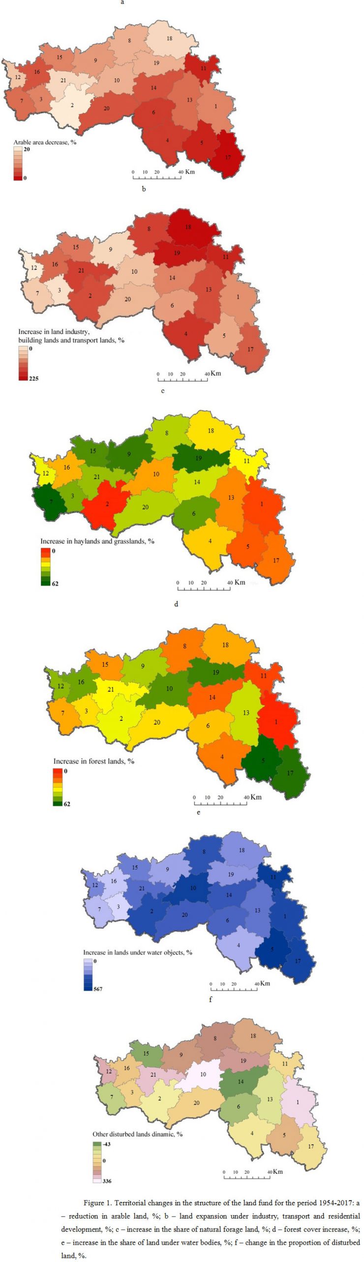
The over 60-year transformation of arable land is less pronounced in the southern and eastern areas of the region (Fig. 1a). The situation is different in Belgorod, Starooskolsky and Gubkin districts where the arable land was mainly reduced due to the transfer of land for individual housing construction (further – IHC). The eastern areas of the region have also undergone a slight change in the structure of the land resources. A map chart of changes in the share of hayfields and pastures (Fig. 1c) demonstrates that distribution is of mosaic type. A map chart of dynamic changes in the land under water facilities (Fig. 1e) has made it possible for us to identify the eastern regions with the greatest positive changes in water content of the territory, which was due to the development of a large number of reclamation ponds. At the same time, one can see a reverse situation developed in the western regions where territorial water content was reported to have less significant increase (within 20-25%). An increase in the region’s area covered by forests was due to political decisions to preserve land resources through the development of forest strips and percent forest cover of unproductive and degraded lands (Fig. 1d).
However, despite some positive trends the forest coved percent failed to have optimal values in the Belgorod Region. A share of land occupied by industrial facilities, transport logistics and residential zone (Fig. 1b) has increased due to the rapid development of urbanization and industrialization of the region, the construction of the largest enterprise of ferrous metallurgy in the country (Starooskolsky Metallurgical Plant), machine building and sugar factories. A growing urban population has resulted in increased share of built-up area. This trend is clearly expressed for the Belgorod district, its population has increased by 1/3 (Chugunova et al., 2019). The districts, which have had a regressive built-up share, include Krasnensky, Krasnogvardeysky and the easternmost districts of the region (Alekseevsky, Valuysky, Veydelevsky, Rovensky).
The mining industry, which is represented by largest iron ore quarries of Gubkin and Starooskolsky districts, as well as by common mineral quarries (chalk, sand, clay), has contributed an increase of area of disturbed lands, which has negatively affected the ecological and resource state of agricultural landscapes (Fig. 1f).
We have conducted a comprehensive assessment of the land transformation using methods of mathematical statistics, which has made it possible to identify reasonably types of municipal districts according to the dynamics of changes in their land resources. As such, we have used a multidimensional cluster analysis, which allows us to structure and break down data into homogeneous types according to aggregation level. The results of classification of 21 municipal districts of the Belgorod Region using hierarchical classification method are presented in Figure 2.
We have managed to combine all parameters of land transformation for the period from 1954 to 2017 with the use of cluster analysis and to ascertain in unbiased way three large clusters, which use dynamic land changes as determinant classification criteria. Land transformation shows that the area of destabilizing land (arable land) has decreased and the area of stabilizing land (natural forage land, forests and lands under water bodies) has increased. This distribution is generally correlated with the physical and geographical zoning and anthropogenic and social nature of the Belgorod Region. An increase in built-up area and land disturbed by industrial development and a decrease in other land not suitable for agricultural use have affected the separate allocation of districts, which include urban agglomerations (Figure 3).
Figure 2: Dendrogram of cluster analysis of 21 municipal districts of Belgorod region (A – coalescence boundary of municipal districts types, D – distance linkage, I-III – groups of the municipal districts, 1-21 – number of municipal districts).
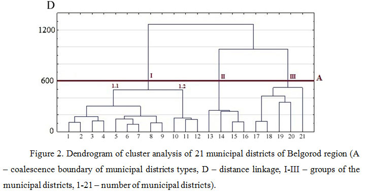
Figure 3: Typization of municipal districts of the Belgorod region on the dynamics of land and resource potential
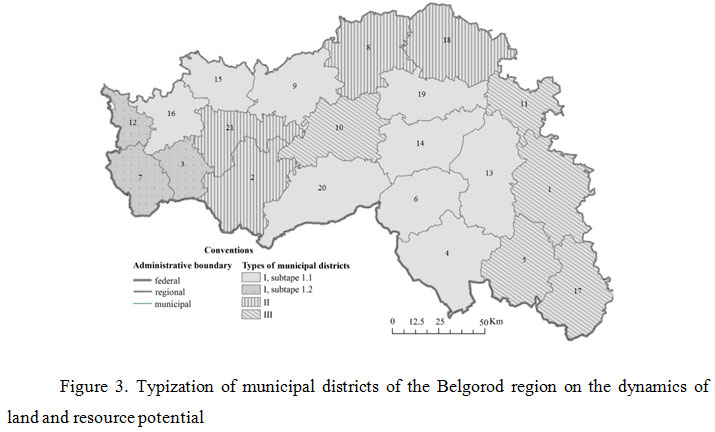
Type I of municipal districts is confined to the forest-steppe zone and characterized by a share of arable land reduced to 12%, natural forage land down to 60% and an increase forest cover percent up to 15%. This type occupies the largest area because it includes 12 districts, which are located in the western and central parts of the region. Having in mind the community distance (D=400), the areas of type I are differentiated by anthropogenic transformation criteria in a more fractional way into two subtypes, which are geographically expressed in the western part of the region (subtype 1.1.), central and eastern parts (subtype 1.2.) respectively. These subtypes are aggregated based on differences in dynamics of land changes under the influence of anthropogenic factors.
Type II of municipal districts is also confined to the forest-steppe zone, but is characterized by a share of arable land reduced to 20%, an increased share of natural forage lands up to 30%, forest cover percent up to 17% and a sharp increase in the share of built-up and industrially developed lands – up to 135%. This type is composed of four districts and includes urban agglomerations.
Type II of municipal districts is confined to the steppe zone. It was reported to have a decrease in arable land down to 12%, an increase in the area under natural forage lands – up to 22%, a higher built-up area – up to 57%, but a significant role in the aggregation of this subtype had an increase in the area of water lands – 200 to 400%. This type includes four districts of the south-eastern part of the region and one district – in the central part.
CONCLUSION
It is preferable to conduct land transformation analysis by chronological sections, which can give a more objective assessment of the past land and resource reformations. It is good to add cluster analysis to statistical information processing, which allows you to structure data based on repeatability of their features, as well as to group them into types at the aggregation level and further to typify the study area by criteria, which meet the working conditions. GIS tools, in particular the ArcGis 10.2 platform, can provide ample opportunities for geospatial analysis. Using Tabulate Area and Zonal Statistics tools, we have managed to identify such municipal areas, which characterized the different degree of land transformation for individual lands, to establish the peak and stagnation of areal changes in the land resources in the Belgorod Region. Spatial and temporal transformations have most affected the arable land. It is typical for all districts of the region to have a negative balance of arable land. The areas under perennial plantations and disturbed lands, which are unsuitable for agricultural use, have slightly decreased. It is reported to have an increase in the lands occupied by industry, transport and buildings, as well as by water bodies, natural forage land and forested land. It is promising to apply the data on land tenure trends obtained with the use of GIS analysis for the implementation of regional land monitoring, as well as in the process of political decision-making on the formation of optimal ecological-economic land balance.
ACKNOWLEDGEMENTS
The study was supported within the intra-university grant of Belgorod State National Research University to support the creation and development of scientific departments – centres of excellence.
REFERENCES
Bao, Ju., Gao, Sh. and Ge, J. (2019). Dynamic land use and its policy in response to environmental and socialeconomic changes in China: A case study of the Jiangsu coast (1750–2015). Land Use Policy, 82: 169–180.
Buryak, Zh. and Grigoreva, O. (2019). A Project-Based Approach to Reduce the Risk of Soil Erosion in Agricultural Landscapes of Small Rivers Basins Using GIS Technologies. International Multidisciplinary Scientific GeoConference Surveying Geology and Mining Ecology Management, SGEM, 19(5.2): 19–26. https://doi.org/10.5593/sgem2019/5.2.
Cai, X., Zhang, X. and Wang, D. (2011). Land Availability for Biofuel Production. Environmental Science Technology, 45: 334–339.
Chendev, Yu.G., Petin, A.N., Serikova, E.V. and Kramchaninov, N.N. (2008). Degradation of geosystems of the Belgorod region as a result of economic activity. Geography and Natural Resources, 4: 69–75.
Chendev, Yu.G., Gennadiev, A.N., Zhidkin, A.P., Belevantsev, V.G. and Vagurin, I.Yu. (2016). Soils in Zone of the Tatar Road Passage. NAUCH VED BELGORO EN, 34(4): 113–123.
Chhabra, A., Geist, H., Houghton, R.A., Haberl, H., Braimoh, A.K., Vlek, P.L.G., Patz, J., Xu, J., Ramankutty, N., Coomes, O. and Lambin, E.F. (2006). Multiple impacts of land use/cover change. In: Lambin E.F., Geist H. (Eds.), Land-Use and Land-Cover Change, Global Change–The IGBP Series. Springer, Berlin Heidelberg, 71–116.
Chugunova, N., Polyakova, T., Ignatenko, S. and Buryak, Zh. (2019). Polarization of the regional settlement system as a reflection of neoliberal urbanization processes. International Multidisciplinary Scientific GeoConference Surveying Geology and Mining Ecology Management, SGEM, 19(5.2): 603–610. https://doi.org/10.5593/sgem2019/5.2.
Comber, A.J., Davies, H., Pinder, D., Whittow, J.B., Woodhall, A. and Johnson, S.C.M. (2016). Mapping coastal land use changes 1965-2014: methods for handling historical thematic data. Transactions of the Institute of British Geographers, 41: 442–459.
Degtyar, A.V. and Grigoreva, O.I. (2018). Development of Land Forests of the Belgorod Region for the 400-year period. NAUCHN VED Belgorod EN, 42(4): 574–586. https://doi.org/10.18413/2075-4671-2018-42-4-574-586.
Felsenstein, D. and Lichter, M. (2014). Land use change and management of coastal areas: retrospect and prospect. Ocean and Coastal Management, 101: 123–125.
Fischer, F. and Black, M. (1995). Greening Environmental Policy. The Politics of a Sustainable Future. Palgrave Macmillan, New York.
Grigoreva, O.I. (2015). The geoinformation analysis of soil and geomorphological communications for the rational organization of agrolandscapes on the basin principles. NAUCH VED BELGORO EN, 3(200): 157–166.
Grigorieva, O.I. (2017a). Evaluation of Distribution Dynamics of Anthropogenic Loads and Ecological State of Ecosystems of Municipal Areas in Belgorod Region. International Research Journal, 9-2(63): 75–80.
Grigorieva, O.I. (2017b). Ecological Information in Land-Cadastral Documentation. Monitoring. Science and Technologies, 3(32): 64–70.
Grigoreva, O.I. and Buryak, Z.A. (2016). Application of basin approach for soil and water protection geoplanning of territory and environmental management. RES J PHARM BIOL CHE, 7(1): 2175–2182.
Kitov, M.V. (2015). Dynamics of area abandoned grassland in the Belgorod region of the period 1990-2010. NAUCH VED BELGORO EN, 9(206): 92–102.
Kitov, M.V. and Tsapkov, A.N. (2015). Assessment of the area of fallow land in the Belgorod region and other regions of European Russia for the period 1990-2013 years. NAUCH VED BELGORO EN, 15(212): 163–171.
Kuzmenko, Ya.V., Lisetskiy, F.N., Kirilenko, J.A. and Grigorieva, O.I. (2013). Providing the Optimum Water Protection Forests Amount at Basin Organization of Nature Management. Izvestia of Samara Scientific Center of the Russian Academy of Sciences, 15(3-2): 652–657.
Lisetskii, F. (2019). Estimates of Soil Renewal Rates: Applications for Anti-Erosion Arrangement of the Agricultural Landscape. Geosciences, 9(6): 266. https://doi.org/10.3390/geosciences9060266.
Lisetskii, F.N., Buryak, J.A., Zemlyakova, A.V. and Pichura, V.I. (2014a). Basin organizations of nature use, Belgorod region. Biogeosystem Technique, 2(2): 163–173. http://ejournal19.com/journals_n/1421944356.pdf.
Lisetskii, F.N., Pavlyuk, Ya.V., Kirilenko, Zh.A. and Pichura, V.I. (2014b). Basin organization of nature management for solving hydroecological problems. Russian Meteorology and Hydrology, 39(8): 550–557.
Lisetskii, F.N., Degtyar, A.V., Buryak, Z.A., Pavlyuk, Ya.V., Naroznyaya, A.G., Zemlyakova, A.V. and Marinina, O.A. (2015). Rivers and water bodies of Belogorye. Belgorod, CONSTANTA.
Lisetskii, F.N., Smekalova, T.N. and Marinina, O.A. (2016). Biogeochemical features of fallow lands in the steppe zone. Contemporary Problems of Ecology, 9(3): 366–375. http://dx.doi.org/10.1134/S1995425516030094.
Lisetsky, F.N., Buryak, J.A., Grigoreva, O.I., Marinina, O.A. and Martsinevskaya, L.V. (2015). Implementation of the basin-administrative and ecoregional approaches to environmentally oriented arrangement inter-settlement areas of the Belgorod region. Biogeosystem technique, 1(3): 50–63.
Manakos, I., Karakizi, C., Gkinis, I. and Karantzalos, K. (2017). Validation and Inter-Comparison of Spaceborne Derived Global and Continental Land Cover Products for the Mediterranean Region: The Case of Thessaly. Land, 6(34). https://doi.org/10.3390/land6020034.
Manakos, I., Tomaszewska, M., Gkinis, I., Brovkina, O., Filchev, L., Genc, L., Gitas, I.Z., Halabuk, A., Inalpulat, M., Irimescu, A., Jelev, G., Karantzalos, K., Katagis, Th., Kupková, L., Lavreniuk, M., Mesaroš, M., Mihailescu, D., Nita, M., Rusnak, T., Stych, P., Zemek, F., Albrechtová, Ja. and Campbell, P. (2019). Comparison of Global and Continental Land Cover Products for Selected Study Areas in South Central and Eastern European Region. Remote Sensing, 10. https://doi.org/10.3390/rs10121967.
Marinina, O.A., Terekhin, E.A., Kirilenko, Z.A., Kurlovich, D.M. and Kovalchik, N.V. (2013). Characteristics Remote Detection Fallow Land Trust and Problems of Agricultural Land Use. Modern problems of science and education, 5. http://science-education.ru/ru/article/view?id=10211.
Nduati, E., Sofue, Yu., Matniyaz, A., Park, J.G., Yang, W. and Kondoh, A. (2019). Cropland Mapping Using Fusion of Multi-Sensor Data in a Complex Urban/Peri-Urban Area. Remote Sensing, 11(207). https://doi.org/10.3390/rs11020207.
Pozachenyuk, E.A., Lisetskii, F.N., Vlasova, A.N. and Kalinchuk, I.V. (2018). Justification of landscape and biotechnical solutions for designing water protection zones. RES J PHARM BIOL CHE, 9(2): 716–722.
Pozachenyuk, E.A., Lisetskii, F.N., Vlasova, A.N., Buryak, Zh.A., Marinina, O.A. and Kalinchuk, I.V. (2015). Model of position-dynamic structure of river basins. RES J PHARM BIOL CHE, 6(6): 1776–1780.
Rinfret, S.R. and Pautz, M.C. (2014). US Environmental Policy in Action-Practice and Implementation. Palgrave Macmillan, New York. https://doi.org/10.1057/9781137482082.
Shifaw, E., Sha, Ji., Xiaomei, L.E., Bao, Zh. and Zhou, Zh. (2019). An insight into land-cover changes and their impacts on ecosystem services before and after the implementation of a comprehensive experimental zoneplan in Pingtan island China. Land Use Policy, 82(2019): 631–642.
Shtompel’, Yu.A., Lisetskii, F.N., Sukhanovskii, Yu.P. and Strel’nikova, A.V. (1998). Soil loss tolerance of Brown Forest Soils of Northwestern Caucasus under intensive agriculture. Eurasian Soil Sci., 31(2): 185–190.
Spesivy, O.V. and Lisetskii, F.N. (2014). Estimate of the intensity and regulation of erosion soil losses in central chernozem region based on the basin approach. Nausch Ved Belgorod En, 10(181): 125–132.
Srivastava, P.K., Mukherjee, S. and Gupta, M. (2010). Impact of urbanization on land use/land cover change using remote sensing and GIS: a case study. International Journal Ecological Econonomics and Statistics, 18: 106–117.
Teluguntla, P., Thenkabail, P., Oliphant, A., Xiong, J., Gumma, M.K., Congalton, R.G., Yadav, K. and Huete, A. (2018). A 30-m Landsat-derived cropland extent product of Australia and China using random forest machine learning algorithm on Google Earth Engine cloud computing platform. ISPRS Journal of Photogrammetry and Remote Sensing, 144: 325–340.
Terekhin, E.A. and Chendev, Yu.G. (2018). Estimation of Forest Cover Changes During modern Period in the South of the Central Russian Upland Using Multiyear Remote Sensing Data. Current Problems in Remote Sensing of the Earth from Space, 15(3): 114–126.
Terekhin, E.A. (2016). Geoinformation approach to monitoring and assessment of crop areas using remote sensing data (a case study of Belgorod region). NAUCH VED BELGORO EN, 18(239): 148–155.
Terekhin, E.A. (2018). Changes in forest cover of ravines-balks network in the south of the central russian upland in recent decades. NAUCH VED BELGORO EN, 42(2): 223–230. https://doi.org/10.18413/2075-4671-2018-42-2-223-230.
Tsapkov, A.N. (2016). Main areas of regional policy for the land plots of individual housing construction as the basis for the welfare of the population. NAUCH VED BELGORO Economics Information technologies, 9(230): 10–20.
Yermolaev, O.P., Mukharamova, S.S., Maltsev, K.A., Ivanov, M.A., Ermolaeva, P.O., Gayazov, A.I., Mozzherin, V.V., Kharchenko, S.V., Marinina, O.A. and Lisetskii, F.N. (2018). Geographic Information System and Geoportal «River basins of the European Russia». IOP Conference Series: Earth and Environmental Science, 107(1): 012108. https://doi.org/10.1088/1755-1315/107/1/012108.
Yudina, Yu. (2013). Mapping of geosystems in Belgorod region: regional aspects. Modern problems of science and education, 6: 933–941.
Zelenskaya, E.Ya., Kukharuk, S.A., Naroznyaya, A.G., Martsinevskaya, L.V. and Sazonova, N.V. (2019). Bioecological Assessment of Arable Soil Pollution: A Case Study of Belgorod Region. Biosci. Biotech. Res. Comm., 12(3): 548–555.
Zhou, X. and Kang, C. (2011). Land use/cover change analysis in Wuhan city based on RS and GIS. 19th International Conference on Geoinformatics, 1–5.
Zia, A. (2012). Land use adaptation to climate change: economic damages from landfalling hurricanes in the Atlantic and Gulf States of the USA, 1900-2005. Sustainability, 4: 917–932.