Mohamed, Yasser Sh. 1,4![]() , Lisetskii, Fedor N. 2*
, Lisetskii, Fedor N. 2*![]() , Budarina, Victoria A3
, Budarina, Victoria A3![]() ,
,
Vinograd, Natalia A.4![]() and Potapov, Alexander A.5
and Potapov, Alexander A.5![]()
1Zagazig University, Sharkia, Arab Republic of Egypt
2Belgorod State National Research University, Belgorod, Russian Federation
3Voronesh State University, Voronezh, Russian Federation
4St. Petersburg State University, St. Petersburg, Russian Federation
5Mining Institute of the Ural Branch, Russian Academy of Sciences, Branch of the Perm
Federal Research Center URO RAS, Perm, Russian Federation,
Corresponding author email: liset@bsu.edu.ru
Article Publishing History
Received: 23/06/2021
Accepted After Revision: 23/09/2021
Groundwater is virtually the only source of water supply to the north of the Sinai Peninsula. Quaternary aquifers are promising for organising reliable drinking water supply at the peninsula. Propagation conditions for Quaternary aquifers were characterised. Information was updated for all existing hydrogeological wells in the North Sinai area. Well logs for the development of the main Quaternary aquifers were compiled; statistical analysis of permeability parameter values for water-bearing rocks was carried out, based on which the zoning was identified according to the permeability coefficient values. Distribution of aquifers with significant thickness in Quaternary deposits is limited only to the coastal plain along the Mediterranean Sea. Based on testing of 52 wells, all Quaternary deposits are characterised by very high permeability coefficients, which on average are tens and even hundreds of metres per day.
Analysis of correlation dependences between the permeability coefficient and the depth of the tested wells showed that there is no unambiguous dependence for all Quaternary deposits or for each of the individual samples. Consequently, ranges of change in the permeability coefficient values for various Quaternary sediments are determined not by the geostatic pressure, but by the packing density of loose rocks and degree of their secondary cementing. Based on the conducted zoning of the area according to the permeability coefficient, the prime areas for underground water production for each aquifer were identified. Performed studies do the groundwork for water that is resource that is more efficient planning and management.
Groundwater Resources, Hydrogeological Zonation, Quaternary Aquifers, Sinai Peninsula.
Yasser Sh. M, Fedor N. L, Victoria A. V, Natalia A. V, Alexander A. P. Justification for Effective Water Planning and Management in the North of the Sinai Peninsula, Egypt. Biosc.Biotech.Res.Comm. 2021;14(3).
Yasser Sh. M, Fedor N. L, Victoria A. V, Natalia A. V, Alexander A. P. Justification for Effective Water Planning and Management in the North of the Sinai Peninsula, Egypt. Biosc.Biotech.Res.Comm. 2021;14(3). Available from: <a href=”https://bit.ly/3yV1Jvb“>https://bit.ly/3yV1Jvb</a>
Copyright © Yasser et al., This is an open access article distributed under the terms of the Creative Commons Attribution License (CC-BY) https://creativecommns.org/licenses/by/4.0/, which permits unrestricted use distribution and reproduction in any medium, provide the original author and source are credited.
INTRODUCTION
Although surface water is the most accessible type of water resources for industrial and agricultural use, it is the most vulnerable to depletion in quantity and quality. Since the river runoff accounts for 89% of the total annual inflow of inland waters into the World Ocean, the rivers play a crucial role in the global water balance. The data on water resources and their use in selected countries and world regions, which were obtained as a result of long-term studies of the State Hydrological Institute (Saint Petersburg) within the framework of the International Hydrological Program of UNESCO and WMO, have shown that the total inflow of river waters from the continents (excluding Antarctica) to the World Ocean is 39,500 km3 per year (Lisetskii 2021).
In addition, the World Ocean receives approximately 2,400 km3 of underground water that are not drained by rivers. In total, the World Ocean receives approximately 44,200 km3 of continental fresh water per year or 300 mm for the entire land area (Shiklomanov 2008). An important feature of any river basin is its hydrological characteristic, which allows calculating the water balance and simulating the spatial moisture content of the entire surface of the catchments based on the received precipitations and their flow rate at the outlet (Ivanov and Lisetskii 1995; Moskalenko et al. 2012; Gusarov 2019; Dragunova et al. 2020; Yermolaev et al. 2021).
The watershed parameters, which are distributed in space and time, are included in the design solutions for the development of the territory, using modern technologies, such as GIS modeling, remote sensing, creation of geoportals (Shtompel et al. 1998; Lisetskii et al. 2014; Yermolaev et al. 2018). A list of top-priority scientific issues in the field of rational use of water resources begins with estimated water stocks on the Earth available to the human race, water consumption rate, and awareness of freshwater shortage as a global problem, it is later transformed into a set of measures needed to address the problems of unsustainable water consumption, water pollution, environmental impacts on other natural environments, and development of design and practical solutions for soil and water protection arrangement of the catchment area (Buryak and Marinina 2020).
In addition, it is nationally important to develop and evaluate procedures for using objective environmental and economic indicators of anthropogenic impacts on water resources, including the ratio of water used to water resources, taking into account the environmental component of runoff; the rate of dilution of wastewater with the river runoff; and indicators of the effectiveness of runoff regulation. While the potential for necessary research, which ultimately aims to overcome the blue water-groundwater and surface water scarcity, is now time to gradually move towards the limits to the green water footprint, the green water flow allocated to human society (Schyns et al. 2019).
Today, there is an urgent need to find additional sources to solve the problem of projected water shortages in the Arab Republic of Egypt. Groundwater is one of these sources. Now the country’s fresh groundwater resources comprise of less than 20% of the total balance of water resources used (Abdel-Shafy and Kamel 2016; Koronkevich et al. 2020).
To cope with problems involving the population growth and the need for its social support, the Government of Egypt focused on the development of the Sinai Peninsula, which is believed to have a high potential for exploration of mineral resources, tourism, and agriculture. The Sinai Peninsula covers an area of 61,000 km2; its population is 559,071 people (Abdel-Shafy and Kamel 2016).
At the same time, the peninsula, which is located far from the major water source, the river Nile virtually has no other water supply sources, other than underground water, at least during the most part of year, beyond of the high-water period. The area of Sinai is completely represented by desert lands, with the exception of its north-eastern part. In general, the Sinai Peninsula is characterised by arid climate: annual precipitation in various regions is estimated at 40 to 200 mm (the latter is north-east) (Mohamed et al. 2020).
Until now, the development of surface waters in Sinai has been implemented in some areas through construction of dams and organisation of temporary reservoirs, functioning only during flood periods. Numerical modelling is successfully used to assess effectiveness of creating artificial aquifers in body of earth dams. In some areas, such as El-Arish in the north-east and El-Tor in the south-west, groundwater is used for drinking or irrigation, extracted mainly from Quaternary sediments at a depth of 50 to 100 m, or more. At the same time, excessive pumping in recent years has significantly deteriorated their quality due to intrusions of sea salt water (Mohamed et al. 2020). This paper studies the Quaternary aquifers, which are promising for organisation of reliable drinking water supply at the Sinai Peninsula.
MATERIAL AND METHODS
The conditions for propagation of Quaternary aquifers in the north of the Sinai Peninsula are characterised by the totality of the results of all studies conducted earlier in this area, including those conducted in recent years, etc. (Arad and Kafri 1980; Shata 1982; Aggour et al. 2007; Elewa and Qaddah 2011; El Samanoudi et al. 2013; Ghoubachi 2013; Raouf 2014; Arnous 2016; Khaled et al. 2016; Ibrahim et al. 2021). The main evidence bases of studies became information on hydrogeological wells contained in the summary report ‘North Sinai Groundwater Resources Study in the Arab Republic of Egypt (JICA, 1992), as well as data provided by the Water Resource Research Institute (WRRI) under the Ministry of Water Resources and Irrigation of the Arab Republic of Egypt (Ibrahim et al. 2021).
As part of this paper, information was updated for all existing hydrogeological wells in the North Sinai area. The result of this systematisation was represented by the corresponding database, which in total includes information on 180 wells, 52 of which open Quaternary aquifers. The authors compiled the well logs for the development of the main Quaternary aquifers and carried out a statistical analysis of permeability coefficient values using the SPSS software, based on which the territorial zoning of North Sinai in terms of the development of Quaternary aquifers in accordance with permeability coefficient values was determined (Ibrahim et al. 2021).
RESULTS AND DISCUSSION
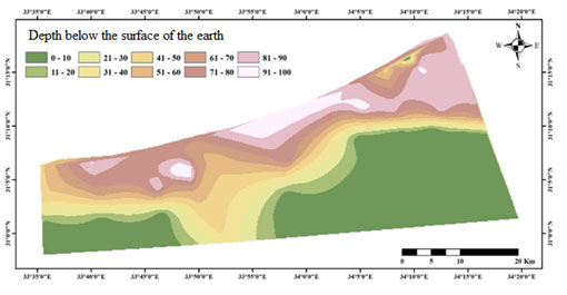
Quaternary formation deposits were widespread in the area under investigation. Nevertheless, the spread of significant aquifers there was limited only by the coastal plain along the Mediterranean Sea. Relatively thick Quaternary deposits stretched along the coastal plain with a line 10 to 15 km wide from the estuarine part of the El-Arish wadi to the Rafah region (Figure 1) and from Bir al-Abd to Rohman, with a line width of about 10 km. Within the indicated line, the overall width of Quaternary deposits varied in a rather wide range, increasing from a few metres at the south boundary of the specified line to 80 to 100 metres in the north (Figure 2). In general, the Quaternary cover thickness to the west of the El-Arish wadi was less than to the east of the same.
Figure 1: Coastal plain map within the Quaternary deposits development
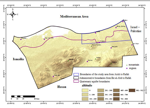
Figure 2: Isopach Map (Total Thickness) of Quaternary Formations
The main water-bearing rocks of Quaternary deposits of the considered area are sand, gravel, and kurkar. Kurkar is limestone sand deposits that are almost ubiquitous in the coastal plain. In the coastal zone, the upper layer is generally represented by sand with a thickness of 20 to 40 m. The sand stratum is composed of sand dune deposits and ancient beach sand. Differentiation of these formations in the lithological profile of the wells is rather difficult.
At the same time, ancient beach sand, covered by dune sands, is usually considered one of the promising aquifers. Gravel or kurkar deposits underlie the sand stratum. The distribution of sand thickness in the El-Arish wadi valley and in the coastal plain as a whole, from Sheikh Zuweid to Rafah, is shown in the figure (Figure 3a).
Gravel strata occur in many areas of the considered area, but as an independent aquifer, this stratum is concentrated mainly in the alluvial valley in the El-Arish wadi area: it stretches for about 10 km along the El-Arish wadi bed. The origin of this gravel is debatable. However, it is clear that it extends beyond the current alluvial valley of the El-Arish wadi, at least north of the El-Arish airport. The distribution of the gravel aquifer thickness is shown in the figure (Figure 3b).
In the coastal plain as a whole, from Sheikh Zuweid to Rafah, gravel layers are observed only in local areas. Obviously, these local deposits have accumulated in old wadis. In most cases, it is noted here that groundwater levels in the wells are established below of the gravel stratus bottom. For this reason, the water abundance of gravel is considered low here.
Figure 3: Isopach Map of the Aquifer Represented by: a) Sands; B) Gravel; C) Kurkar
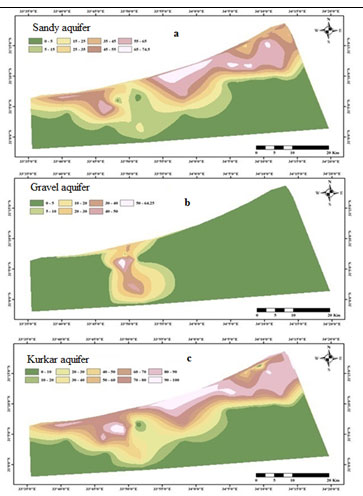
Kurkar deposits are widespread within the coastal plain, in the area from Sheikh Zuweid to Rafah, under the deposits of sand dunes. The absolute elevation of the kurkar deposit base ranges from -60 to -20 m. Its thickness varies from 10 to 40 m. In some parts of the coastal zone of sand dunes, kurkar is pinched out. The distribution of these deposits by thickness is shown in the figure (Figure 3c). In wells of the alluvial valley of the El-Arish wadi, kurkar is traced for 10 km along the wadi bed and is overlain by gravel. In this zone, filters of most wells are fitted precisely for the kurkar deposits.
Using the SPSS software, statistical estimates for the distribution of values of the permeability coefficient, K (m/day), obtained because of field-testing of wells, were carried out. For Quaternary deposits, different data samples were considered depending on the sampled aquifers and sampling areas: 1) general population for all Quaternary deposits (Qtotal); 2) joint sampling (single filter) for gravel and kurkar deposits: in the El-Arish wadi valley (kurkar + gravel_A); 3) kurkar deposits on the north-eastern coast of the study area, in the districts of El-Arish, Sheikh Zuweid, and Rafah (kurkar_ASR); 4) sandy deposits on the north-eastern coast of the study area in the same areas of El-Arish, Sheikh Zuweid, and Rafah (sand_ASR); and 5) sandy deposits in the north-western region of Bir al-Abd (sand_BaA). The calculated results for the statistical parameters are shown in Table 1.
Table 1. Statistical parameters of distribution of the permeability coefficient values (K, m/day) in the Quaternary deposit aquifers
| Indicator | Qtotal | Kurkar + Gravel_A | Kurkar_ASR | Sand_ASR | Sand_BaA |
| Number of measurements | 52 | 31 | 11 | 6 | 4 |
| Average | 118 | 120 | 75 | 45 | 327 |
| Median | 92 | 102 | 77 | 37 | 361 |
| Standard deviation | 106 | 91 | 54 | 19 | 149 |
| Minimum | 2.7 | 21 | 2.7 | 29 | 131 |
| Maximum | 457 | 360 | 177 | 77 | 457 |
As can be seen from Table 1, according to the results of testing of 52 wells, all Quaternary deposits are characterised by very high permeability coefficients, on average tens and even hundreds of metres per day, with an absolute single minimum of 2.7 m/day (kurkar). At the same time, kurkar and gravel deposits are characterised by a very large scatter of permeability coefficients: the minimum and maximum values differ by tens (practically up to a hundred) times. Most probably, this is caused by different degrees of cementing of these rocks at different sampling areas.
On the contrary, sandy deposits are simpler in terms of permeability: minimum permeability coefficients differ from maximum ones only by 2.5 to 3.5 times. But at the same time, the average value of the permeability coefficient for the sands to the west of the El-Arish wadi (in the Bir al-Abd region) was on the whole the highest among all the tested land sites of Quaternary deposits (327 m/day), and about 7 times more than in the sands of the eastern area, in the areas of El-Arish, Sheikh Zuweid, and Rafah.
Conclusions made in relation to sands should be considered now to be conventional requiring further clarifications due to rather small number of samples. The correlation field and the relationship between the permeability coefficient (K) and the depth of the investigated well (ds) for all wells adapted for Quaternary deposits are shown in the graph in Figure 4.
Figure 4: Correlation Dependence between the Permeability Coefficient (K, m/day) and the Well Depth (ds, m) for all Wells Fitted for Quaternary Deposits
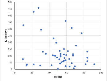
No unique dependence (trend) for all Quaternary deposits either as a whole or for each individual sampling was found. Thus, it should be assumed that within the development of Quaternary rocks to the established depths not exceeding 100 metres, there was no change in permeability properties of rocks with the depth increase. Therefore, the stated above value ranges for permeability coefficients of different Quaternary deposits were determined not by the rock pressure, but by the packing of loose rocks and by the degree of their secondary cementing, which developed both directly during the deposition and during the following secondary processes, apparently associated with ground water filtration.
It is also important to note that, as shown earlier of the spatial and temporal analysis of the unconfined aquifer (Nema et al. 2017), there is a good hydraulic connection of groundwater level with the rainfall. Investigating hydraulic connections in complex hydrological systems shows the key role of geological heterogeneity in water-bearing horizons (Pang et al. 2020; Wang et al. 2020).
It is also important to note that, as shown earlier of the spatial and temporal analysis of the unconfined aquifer, there is a good hydraulic connection of groundwater level with the rainfall (Nema et al. 2017). Based on the results of statistical data processing, areal (in plan) zoning of the development area for Quaternary deposits was conducted according to the values of permeability coefficients of water-bearing rocks, within the coastal plain up to 15 km wide, which is extremely important from the point of view of assessing the prospects for water supply of the area under consideration. It should be noted that aquifers with the participation of kurkar (local term for aeolian carbonate-cemented, quartz sandstone) have significant specificity in terms of permeability compared, for example, with sands (Galili and Zviely 2019; Bao et al. 2021; Tasalloti et al. 2021).
Permeability zoning of the coastal plain was carried out, similar to statistical estimates, separately for the areas of development of various rock types: 1) for combined aquifer represented by kurkar deposits and gravel (single filter) in the El-Arish area and aquifer of kurkar deposits on the north-eastern coast of the study area (in the western part of the coastal plain, these deposits were not sampled) (Figure 5), and 2) for aquifer, composed of sands and developed both on the north-eastern coast of the study area, in the areas of El-Arish, Rafah, and Sheikh Zuweid, and in the north-west, in the area of Bir al-Abd (Figure 6).
It should be noted that aquifers with the participation of kurkar (local term for aeolian carbonate-cemented, quartz sandstone) have significant specificity in terms of permeability compared, for example, with sands (Galili and Zviely 2019; Bao et al. 2021; Tasalloti et al. 2021).
Figure 5: Zoning Map of Development Area for the Aquifer, Represented by Kurkar and Gravel Deposits, according to the Permeability Coefficient, K, m/day
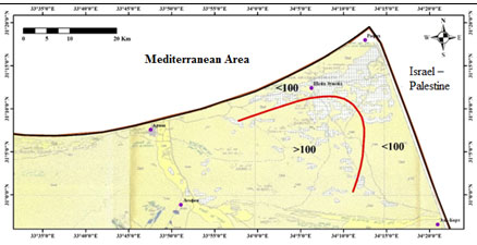
Figure 6: Zoning Map of Development Area for the Aquifer, Represented by Sand Sediments, according to the Permeability Coefficient, K, m/day
As shown in Figure 5, in the most north-eastern part of the area under consideration, near the border of the Republic of Egypt with the Gaza Strip and Israel, the permeability coefficient in the aquifer represented by the kurkar deposits will be less than 100 m/day (K < 100 m/day), and in the rest of the region, in the El-Arish wadi area and in the inner parts of the study area, where gravel aquifer is additionally developed, the permeability coefficients will generally be more than 100 m/day (K > 100 m/day).
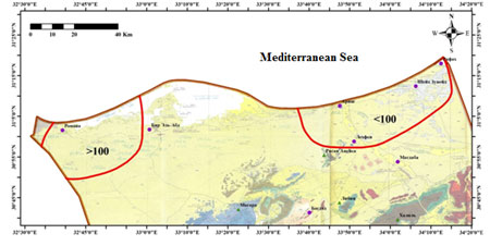
Consequently, the development of water supply at the expense of horizons, represented by kurkar and gravel deposits, is more promising in the El-Arish wadi area than in the north-eastern regions of North Sinai. As shown in Figure 6, in the aquifer represented by sands, in all north-eastern regions of North Sinai (both El-Arish, Rafah, and Sheikh Zuweid), the permeability coefficients are less than 100 m/day (K < 100 m/day), and in the north-west of North Sinai, in the Bir al-Abd region, they are more than 100 m/day (K > 100 m/day).
Thus, it is preferable to organise water supply from the sand aquifer in the regions of the north-western part of North Sinai in comparison with the north-eastern part. Discussing these results, one cannot fail to mention the interaction of groundwater with the sea areas of the Mediterranean Sea. As shown by previous research (Gad and Khalaf 2015; Elshinnawy and Almaliki 2021), the difference between the maximum and the minimum water table is in the tide range of the eastern region of the Mediterranean Sea, and the groundwater resources, in particular in the North Sinai area, were found to be affected by salt water due to over-pumping phenomenon.
CONCLUSION
The findings of the present study suggests that an important and still underestimated aspect of the problem of water resources management in the catchment area is to study the underground and surface water relationship, which tends to be modified due to geological structure differences for any given territory. This is, in particular, due to the fact that when the quality of river water is reduced according to the drinking water supply standards, there is a transition to the use of underground water as the main source for domestic drinking, industrial, and agricultural water supply.
In arid regions, such as the north of the Sinai Peninsula, groundwater is virtually the only water source used by local communities. Obviously, extraction of groundwater from aquifers in areas with high water availability will be easier and cheaper than in other areas, and, therefore, the development of these areas will be more intensive. Therefore, the studies conducted do the groundwork for more efficient water planning and management, since in fact they form the basis for further zoning of the area in terms of groundwater resources.
Conflict of Interests: Authors had no conflict among their interests to disclose.
REFERENCES
Abdel-Shafy, H I and Kamel A (2016) Groundwater in Egypt issue: resources, location, amount, contamination, protection, renewal, future overview. The Egyptian Journal of Chemistry Vol 59 No 3 Pages 321- 362.
Aggour, T A, Hewidy, A A, Attia, S H et al. (2007) Geology of water resources at Wadi Geraia Basin, Sinai, Egypt. United Arab Republic Journal of Geology Vol 51 Pages 177-204.
Al-Madhhachi, A-S T, Rahi, K A and Leabi, W K (2020) Hydrological impact of Ilisu Dam on Mosul Dam; the River Tigris. Geosciences No 10 Art 120.
Arad, A and Kafri U (1980) Hydrogeological inter-relationship between the Judea Group and the Nubian sandstone aquifers in Sinai and the Negev Israel. Journal of Earth-Sciences Vol 29 Pages 67-72.
Arnous, M O (2016) Groundwater potentiality mapping of hard-rock terrain in arid regions using geospatial modelling: example from Wadi Feiran basin, South Sinai, Egypt Hydrogeology Journal of Springer Vol 24 Pages 1375–1392.
Bao, Y, Liu, Q, Du, X et al. (2021) Division of glutenite lithofacies based on the tri-element of gravel-matrix-fracture. Diqiu Kexue – Zhongguo Dizhi Daxue Xuebao. Earth Science – Journal of China University of Geosciences Vol 46 No 6 Pages 2157-2171.
Buryak, Zh A and Marinina O (2020) Using GIS technology for identification of agricultural land with an increased risk of erosion. E3S Web of Conferences Vol 176 Art 04007.
Dragunova, S, Kuznetsov, E, Khadzhidi, A et al. (2020) Investigating the effectiveness of a fish-protection structure of the reclamation water intake. E3S Web of Conferences Vol 210 Art 07008.
El Samanoudi, M A, Ebid, G S, Rofail, N N et al. (2013) Assessment of groundwater resources in northeastern Sinai Peninsula constrained by mathematical modeling techniques. J. Earth Sci. Eng, No 1 Pages 23-34.
Elewa, H H and Qaddah A (2011) Groundwater potentiality mapping in the Sinai Peninsula, Egypt, using remote sensing and GIS-watershed-based modeling. Hydrogeology Journal of Springer-Verlag Vol 19 Pages 613–628.
Elshinnawy, I A and Almaliki, A H (2021) Al Bardawil lagoon hydrological characteristics. Sustainability (Switzerland) Vol 13 No 13 Art. 7392.
Gad, M I and Khalaf, S (2015) Management of groundwater resources in arid areas case study: North Sinai, Egypt. Water Resources Vol 42 No 4 Pages 535-552.
Galili, E and Zviely, D (2019) Geo-archaeological markers reveal magnitude and rates of Israeli coastal cliff erosion and retreat. Journal of Coastal Conservation Vol 23 No 4 Pages 747-758.
Ghoubachi, S Y (2013) Contribution to the hydrogeology of the Lower Cretaceous aquifer in east Central Sinai Egypt. Journal of King Saud University – Science Vol 25 No 2 Pages 91-105.
Gusarov, A V (2019) The impact of contemporary changes in climate and land use/cover on tendencies in water flow, suspended sediment yield and erosion intensity in the northeastern part of the Don River basin, SW European Russia. Environmental Research Vol 175 Pages 468–488. https://doi.org/10.1016/j.envres.2019.03.057
Gusarov, A V, Sharifullin, A G and Komissarov, M A (2021) Contemporary long-term trends in water discharge, suspended sediment load, and erosion intensity in river basins of the North Caucasus Region, SW Russia. Hydrology No 8 Art 28.
Ibrahim, E H, Shereef M R, El Galladi A A et al. (2004) Geoelectric study for Quaternary groundwater aquifers in northwest Sinai, Egypt. Egypt. Geophys. Soc. J. Vol 2 No 1 Pages 69-74.
Ivanov, I V and Lisetskii F (1995) Manycentury periodicity of solar-activity and soil formation. Biofizika Vol 40 No 4 Pages 905-910.
Khaled, M A, Al Tammamy A M, Barseem M S et al. (2016) Geoelectrical and hydrogeological study to delineate the geological structures affecting the groundwater occurrence in Wadi El Khariq Basin, Northwest El Maghara, North Sinai. Egypt. Arab journal of Geosciences Vol 9 No 4 Pages 1-19.
Koronkevich, N I, Barabanova E, Georgiadi A et al. (2020) Environmental and economic indicators of anthropogenic impacts on water resources in Russia and the World. Herald of the Russian Academy of Sciences No 4 Pages 428-436.
Lisetskii, F N (2021) Rivers in the focus of natural-anthropogenic situations at catchments. Geosciences (Switzerland) Vol 11 No 2 Art 63 Pages 1-6. DOI: 10.3390/geosciences11020063.
Lisetskii, F N, Pavlyuk Ya, Kirilenko Zh et al. (2014) Basin organization of nature management for solving hydroecological problems. Russian Meteorology and Hydrology Vol 39 No 8 Pages 550-557.
Masoud, A A, Meswara, E A, El Bouraie, M M et al. (2018) Monitoring and assessment of the groundwater quality in wadi Al-Arish downstream area, North Sinai (Egypt). Journal of African Earth Sciences No 140 Pages 225-240.
Mohamed, YS, Vinograd N, and Potapov A (2020) Аssessment of the filtration through earth dams when changing their parameters using the Z_SOIL software. Vestnik Voronezhskogo gosudarstvennogo universiteta. Serija: Geologija = Proceedings of Voronezh State University. Series: Geology No 2 Pages 90-97. DOI: 10.17308/geology.2020.2/2863
Moskalenko, A P, Kalinichenko V, Moskalenko S et al. (2012) Ecological and economic methodological aspects of the innovative soil processing justification. Herald of South Russia State Technical University (NPI). Series: Socio-economic sciences No 4 Pages 114-123.
Nema S, Awasthi M K and Nema R K (2017) Spatial and temporal ground water responses to seasonal rainfall replenishment in an alluvial aquifer. Biosc. Biotech. Res. Comm. Vol 10 No 3 Pages 431-437.
North Sinai Groundwater Resources Study (1992) North Sinai Groundwater Resources Study in the Arab Republic of Egypt, Japan International Cooperation Agency (JICA) and final report submitted to the Research Institute for Water Resources, Egypt, Cairo, Water Res. Center, Ministry of Public Works and Water Res. Pages 214.
Pang, L, Abeysekera, G, Hanning, K et al. (2020) Water tracking in surface water, groundwater and soils using free and alginate-chitosan encapsulated synthetic DNA tracers. Water Research No 184 Art 116192.
Raouf, OA (2014) Investigation of groundwater flow heterogeneity in fractured aquifers (Case study: Qusiema area, North Sinai). International Journal of Water Resources and Environmental Engineering Vol 6 No 11 Pages 279-286.
Schyns, J F, Hoekstra A, Booij M, et al. (2019) Limits to the world’s green water resources for food, feed, fiber, timber, and bioenergy. Proceedings of the National Academy of Sciences of the United States of America No 11 Pages 4893-4898.
Shata, A A (1982) Hydrogeology of the Great Nubian Sandstone basin Egypt. Quarterly Journal of Engineering Geology and Hydrogeology Vol 15 Pages 127-133.
Shiklomanov, I A (2008) Water resources of Russia and their use; State Hydrological Institute (Edited by Shiklomanov I A) – St Petersburg 600 рages. ISBN 978-5-98147-006-6.
Shirokov R S (2019) Formation of geoecological conditions of the coastal marine region of the Western Yamal under climate change. NAUCH VED BELGORO EN. Vol 43 No 4 Pages 412–424 (in Russian). ttps://doi.org/10.18413/2075-4671-2019-43-4-412-424
Shtompel, YA, Lisetskii FN, Sukhanovskii YP et al. (1998) Soil loss tolerance of Brown Forest Soils of Northwestern Caucasus under intensive agriculture. Eurasian Soil Science Vol 31 No 2 Pages 185-190.
Singh, B, Kant, K, Garg, M et al. (2019) A comparative study of radon levels in underground and surface water samples of Faridabad district of Southern Haryana, India. Journal of Radioanalytical and Nuclear Chemistry Vol 319 No 3 Pages 907-916.
Tasalloti, A, Chiaro, G, Murali, A et al. (2021) Physical and mechanical properties of granulated rubber mixed with granular soils – a literature review. Sustainability (Switzerland) Vol 13 No 8 Art. 4309.
Wang, W-S, Oswald, S E, Gräff, T et al. (2020) Impact of river reconstruction on groundwater flow during bank filtration assessed by transient three-dimensional modelling of flow and heat transport. Hydrogeology Journal Vol 28 No 2 Pages 723-743.
Yermolaev, O P, Mukharamova S and Vedeneeva E (2021) River runoff modeling in the European territory of Russia. Catena Vol 203 Art 105327 DOI: 10.1016/j.catena.2021.105327.
Yermolaev, O P, Mukharamova S, Maltsev K et al. (2018) Geographic Information System and Geoportal “River basins of the European Russia”. IOP Conf. Series: Earth and Environmental Science Vol 107 No 1 Art 012108. DOI: 10.1088/1755-1315/107/1/012108.
Zeinali, M, Azari, A and Heidari, M M (2020) Multiobjective optimization for water resource management in low-flow areas based on a coupled surface water–groundwater model. Journal of Water Resources Planning and Management Vol 146 No 5 Art 04020020.